The 2017 eclipse, named "The Great American Eclipse" by the then new web site www.greatamericaneclipse.com also referred to the 2024 eclipse as "The Great North American Eclipse." As their web site grew in something that looks at many eclipses great and small throughout the world they appear to have mostly dropped that term. It fits nicely, a this one goes across parts of Mexico, the States, and Canada.
The track crossed northeast Ohio, where I grew up, and near Buffalo, where some in-laws live. While it crossed very northern New Hampshire, the closest I would be to totality was in Vermont and that's where I decided to go. April offers scarce sunlight in New England worse in the lee of the Great Lakes. If I got clouded out, I'd have wasted less travel.
So, I planned for a solo trip to Vermont. In Oregon in 2017 it was easy to find places in the national forests for camping, not so easy here, especially the nearby populations centers that people expected would overrun the path of totality. I decided to make it a day trip and visited the Lamoille River Valley where a rail trail offered some mobility options if the place was jammed.
|
|
While searching on Google Maps for promising sites I focused on corn fields.
I had no idea how crowded things would be, so a corn field next to the rail
trail offered a lot of space. I knew the sun would be pretty high in the sky,
but Vermont has hills and trees to worry about. If the overcast was too
dense, perhaps I could at least see the moon's shadow race by overhead.
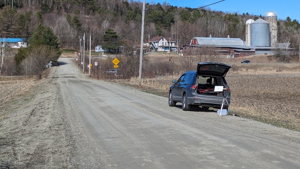
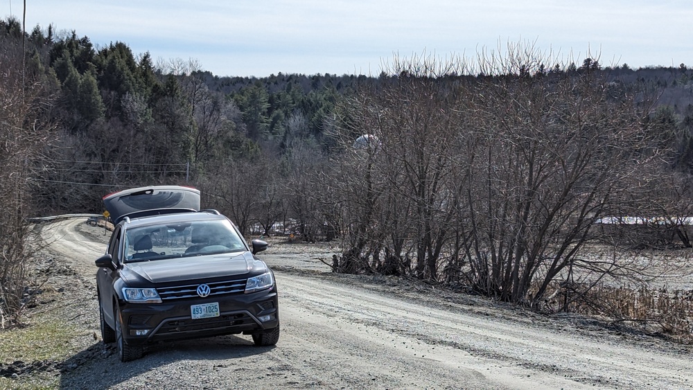
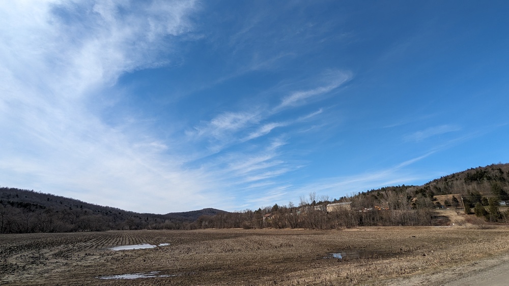
My first choice was in the small town of Hyde Park. In my pre-trip visit I went there first but got a look at my second choice outside of Wolcott as I drove past. I hadn't realized until the day before that VT 100 joined VT 15 around Hyde Park and I really wanted to stay east of that popular north-south road. Stowe was ten miles south and I was afraid that if Stowe filled up, people might head north. Hyde Park is a nice little town with a nice little restaurant, Two Son's Bakehouse. A small parking area for the rail trail was next to the town's leach field, okay, but there were No Trespassing signs on that field. It was a workable spot, but perhaps best left for the local residents. My third choice was several miles further west on a side road north of a corn field. Instead of going there, I turned back to the spot I drove by earlier. This was on a dirt road between corn fields that continued on past a couple farms and then continued up the hill. I went up that way a bit, but it was still mud season there so I turned back. Later I saw on the maps a protected area that might have been a quiet spot to get away from crowds. On eclipse day I took I-89 to I-91 and ran into much more traffic and delays than I expected. To my surprise few people got off in St. Johnsbury, and US Rt 2 and VT Rt 15 had no traffic problems. I passed a couple of good viewing sites along Rt 2 with parking areas, they were mostly full but not overflowing. On VT 15 there were just a few viewers at road intersections and nearly no traffic. Pretty much all the snow from our snow storm a few days earlier had melted. So I parked in the middle of things. These photos are the views to the north, south and west. Note the cirrus overcast. |
|
|
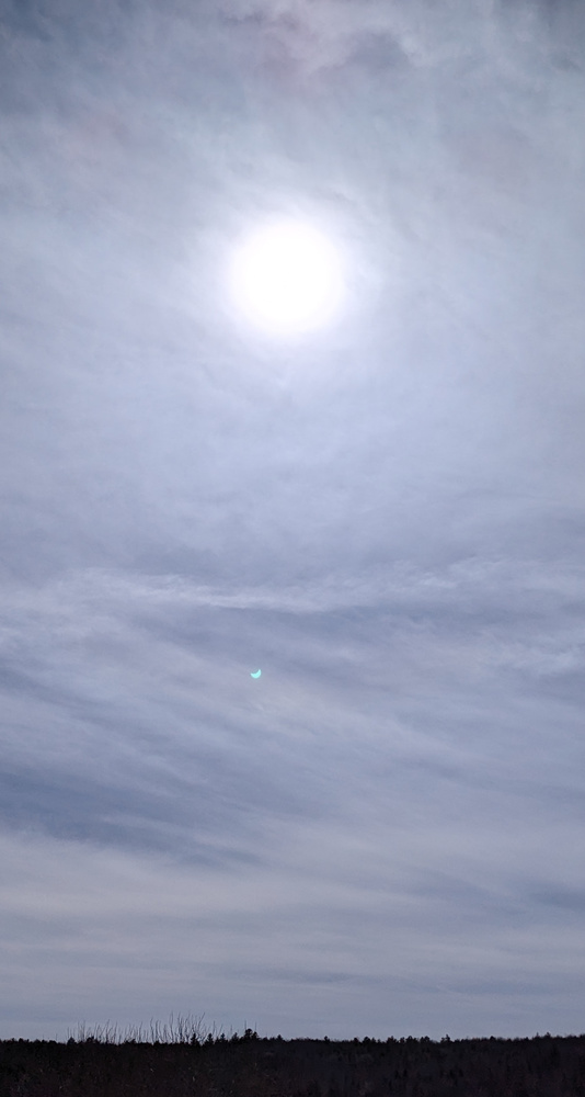
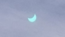
"First contact" has already occurred (so much for the reading material I brought to read before the start), and "second contact" (i.e. totality) was only half an hour away. A quick check with my eclipse glasses reassured me that I could still see the edge of the sun despite the overcast. The tall photo makes things look worse than they really were. The image below enlarges a small lens reflection that shows the sun with a bite taken out of it by the moon.
|
|
|
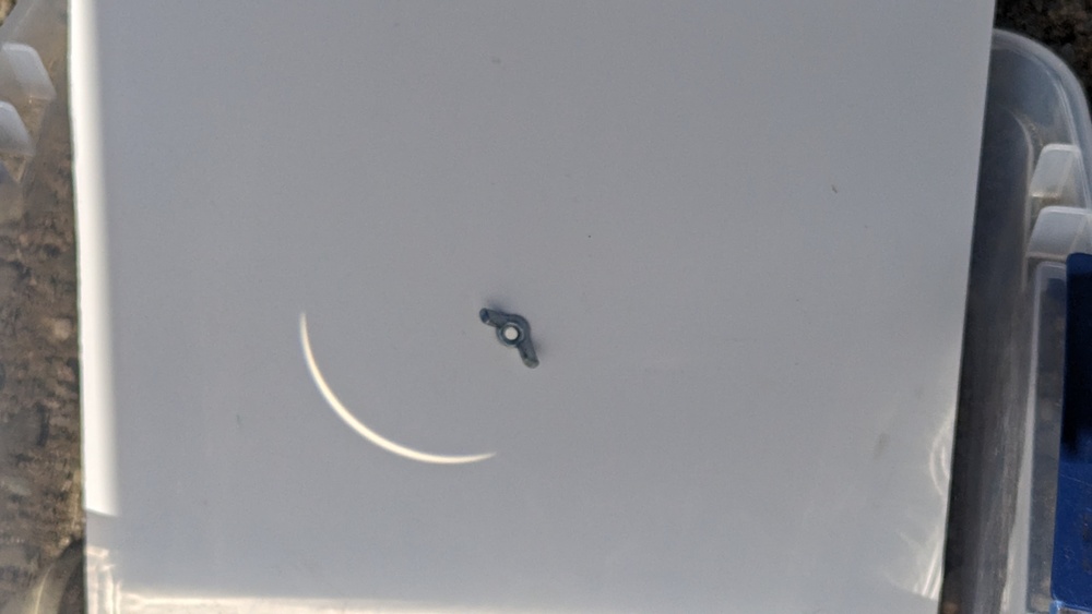
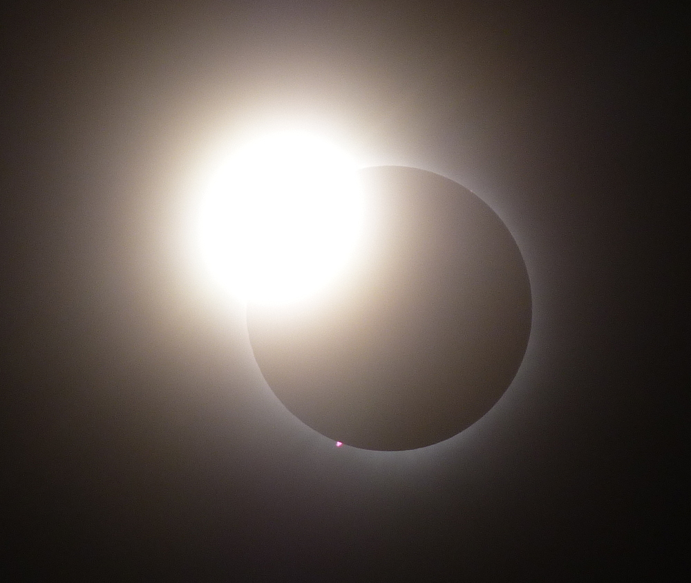
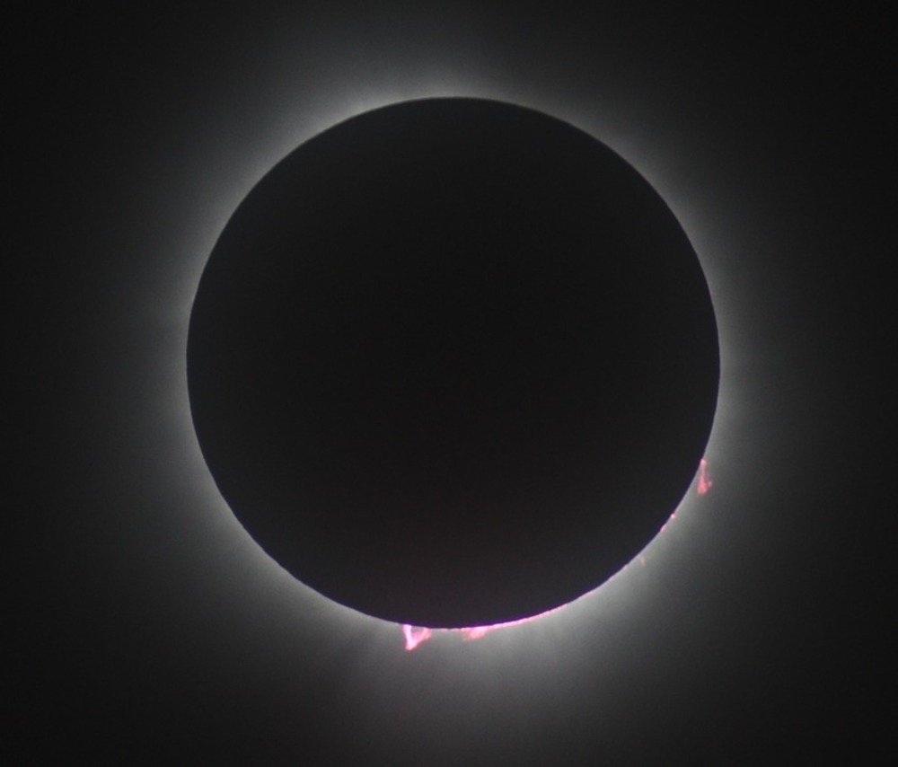
I have disposable eclipse glasses left over from the 1994 annular eclipse and bought similar stock "opera eclipse glasses" this year. They're a 2X binocular with a pair of Galilean telescopes (from molded plastic lenses) with solar filters. By far my favorite viewing option is my system described in the home page - a 8x20 mm monocular projecting on to matboard. It gives a much bigger image that improves as totality approaches and the ambient light decreases. The first image is from the projection at 3:25:17, a couple minutes before totality. I forgot to bring my "real" camera in 2017, and brought it this year as sort of an afterthought. I didn't bring a tripod for it, and I'm very surprised I got a decent diamond ring photo - hand-held and at full zoom. The cirrus overcast made for a bigger diamond and may have helped the camera with exposure. One thing that caught me off guard in 2017 was the accelerating darkness that swept over us. I didn't get that sense in 2024. Perhaps it was from paying more attention to photography this time, it looks like the longer the maximum duration of totality there is also means that the rate of darkening decreases. I haven't seen a good analysis on the web, so I may take the time to plot solar surface area exposed over a minute before totality for different ratios of moon to sun size. That might be a good exercise for Matlab or AI. Feel free to beat me to it. Once in totality, I was surprised that the corona was smaller than I expected. I thought it might have been due to the overcast, but later I discovered that solar activity had declined quite bit over the last couple of weeks. I pulled out my binoculars, also an afterthought, and saw one very bright prominence. That's visible in the photo. |
 |
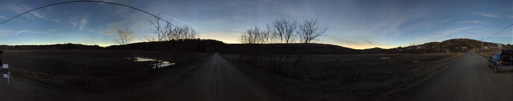
First time observers are often told to just take in the full experience and don't bother with photography - there will be many excellent to stunning photos to view later. That's a good recommendation for almost any total solar eclipse. Given my corn field site, I had decided that my main goal was to capture the twilight panorama at the top of the page during totality. A few days after the eclipse I came across this photo from Bill DiPuccio taken with appropriate equipment and with a similar overcast. This is about as good as it gets without excessive post-processing. Thank you, Bill, for letting me share it here.
|
It appears that not all Boston drivers come from Massachusetts. I was quite amazed at two vehicles that passed me on VT 15. Apologies for the momentary video glitches and the malpositioned rear camera. The clock is slow by one hour (EDT) and two minutes (battery based clock).
I didn't see the first twit in my rear view mirror. In the minute or so before this clip he had his four-way blinkers on. I think he nearly made a left turn, but decided that wasn't the one he wanted and then sped up and saw the one in the video. I expected him to take the turn wide and run into the trees or brake hard in the left lane, so I wouldn't rear-end him. I had to brake myself and let him know I was close behind. That included a little bit of letting him know what I thought of his actions.
One twit would have been enough, but 15 minutes later another, even more clueless, passed me around a bend in the road and then two more vehicles before the crest of a hill. For a while I had a better view of any vehicles beyond the crest than he did. Had someone been coming the other way it would have been very ugly.
I did a poor job estimating traffic issues. In my defense, so did almost everyone else, it's the nature of the beast. It took me a few days to figure out everything, but I think I have, and I think it's kind of interesting. Unless you were there, you'll find it boring, except maybe for my thoughts about how people chose their destinations and routes. The rest of this won't be of much use when the next total solar eclipse comes to New England.
Before the eclipse the two main destinations I heard discussed were Burlington VT and the far northern NH. I ruled out the latter without looking at it. Taking the main road home, US Rt 3, would mean some 60 miles on a two lane highway and merging with other traffic at I-93 which is also one lane southbound through Franconia Notch. Some people who went that way made it home in southern NH at 3 AM. Worse than I expected!
Similarly, I wanted to stay far away from Burlington. Getting out of there back to NH means crossing the state, not an easy task! Two lanes southbound on I-89 (really southeast) is the only sensible route in low traffic times, the best alternative, US 7 south to US 4 east would be out of the way and probably had a lot of traffic too. They might have been faster in the evening.
Some friends left Burlington at 5PM and got home in Massachusetts around 1:45 AM. Normally a four hour or so trip, traffic gradually improved but was heavy all the way to I-495, northwest of Boston.
I left home late morning at 11:21 AM. Android Auto soon announced that traffic was heavier than usual, and I'd reach my destination at 1:54 PM, about 2 ½ hours instead of the 2 hours with normal traffic. For quite a while after that it would say the destination was still 2 ½ hours away. Ultimately I drove for 3h16m and got there at 2:37PM, after the partial phase had started!
My route up used I-89 in NH (heavy traffic), I-91 in VT (frequent slowdowns and where I lost most of my time), US 2 (amazingly light traffic, with groups of eclipse watchers along the way), and VT 15 (essentially no traffic, much to my amazement). From that, things I've read and answers to "Why did you pick there," I think a lot of people picked biggish towns along the interstate highways they were intending to use. That's one reason why Burlington was so popular. In New Hampshire everyone would wind up on US 3 because I-93 heads into Vermont. On I-91 there were a lot of people from states all along the eastern seaboard, and many of them likely knew little about VT. So taking I-91 up to someplace close to the center line of totality is a sensible, well, simple first pass. While I was surprised at how little traffic was on US 2, several people may have gotten off in that area, St Johnsbury, pretty close to the edge of totality. Many others headed for Newport, close to Canada and much closer to the center-line.
This was very different than my intention of staying well away from Burlington. I wanted to get north of that area then head toward the center line, US 2 and VT 15 was the first best chance of doing that. I also know that the duration of totality increases quickly as you get away from the edge and is quite satisfactory for most of the way across the path.
People tend to dribble to their view spot over hours (and days) before an eclipse, and a lot of them leave minutes after totality. Everything you experience post-totality you experienced before and none of it has the awesomeness of totality, so why not try to beat the rush? This is a perfect setup for a massive traffic jam, a very good reason to leave early.
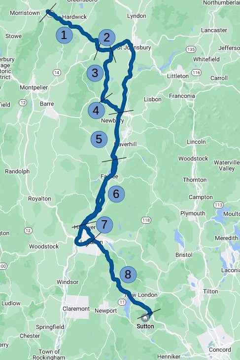
I was confident that traffic would be much worse for me no matter what, so I spent a little time looking at a map before I left. The area I was in had intermittent cell coverage so I wouldn't be able to see what lay ahead, though I did scroll around the area a head of time to preload maps. The main thing I was looking at were US highways that parallel I-91 and avoiding the I-89/I-91 interchange by going through Hanover
Look at the map and follow along for each section. BTW, this is excessive detail, I wrote it more for me than for you!
 |
|
All told, Google says this route will take 2h38m in light traffic. Amazingly, that's exactly what the return trip took! Google's preferred route uses the Interstate highways and should take about half an hour less time in light traffic.
Clearly I beat the rush, but how? I think that a lot more people headed to Newport than I expected and in light traffic it should have taken 55 minutes to get where I got on I-91, It took me 69 minutes, a little longer, but perhaps traffic on I-91 was slower.
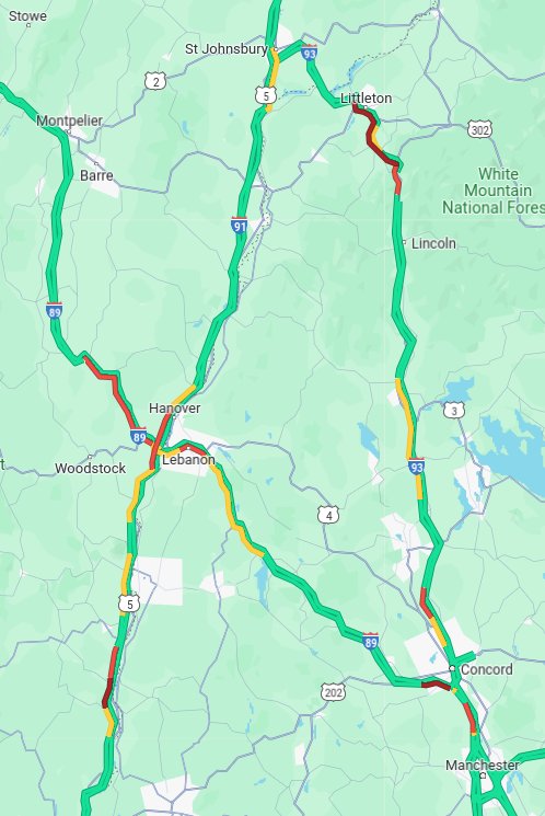 |
I got home at 6:30 PM, I didn't check on traffic until the 11 PM news when I was a bit surprised that people were still in heavy traffic in VT. I wasn't surprised about the those who went to northern NH. After the weather report I checked the traffic on Google Maps. Yeah, I beat the rush! I'd love to see a time-lapse video of this map. |
Driving in I-91 was interesting and in some ways refreshing. Well, getting rid of all the cars would have made it more refreshing, but then I wouldn't have felt the urge to include this section. Consider who I was sharing the road with. People who are comfortable with a long drive. People who are knowledgeable enough to understand why a 99% partial eclipse is vastly inferior than 100%. People who know traffic will be bad.
The first thing I noticed is that few people were changing lanes and that everyone was making the same progress. The two lanes were not perfectly in sync, sometimes one lane would gain on the other, sometimes the opposite. These were often in "traffic waves." One fairly clueless driver in the right lane got jealous that the left lane was making better progress and that I had left a space ahead of me that she could merge into. So she did. She had not noticed we were in a period of alternating fast and slow traffic. I had seen that several cars ahead there were brake lights showing that a traffic wave ahead was working its way back to us. She had to brake suddenly as we entered our slow phase. Now the right lane was moving better and she move back there and may have lost a couple places in that lane.
Something like 10 minutes later we passed each other again, she seemed to have figured out that it was smarter to stay in a lane. There were several distinctive cars that I changed places in out lanes. E.g. the car from South Carolina, the van with corporate lettering on the side.
I settled on hanging out in the right lane as I could leave a bigger gap to the car in front of me and anyone who had hopes of gaining time in the passing lane was less likely to merge right than in the opposite situation. When coming up on an interchange I'd often move left to reduce the interactions with anyone joining us.
I first read about traffic waves decades ago in Scientific American in an article that studied traffic slowdowns in the Holland tunnel in New York City. They concluded the trigger was that drivers transitioning from the downhill stretch to the uphill stretch were unaware that they were slowing down a bit. The next driver would notice that a second or two later and after a reaction delay would slow down a bit more. This began a positive feedback loop that ultimately led to stop and go traffic. Their solution was to add? test? metering stop lights to introduce gaps in the traffic flow and let a new wave of traffic through that was short enough to not develop the stop and go pattern.
The same thing seemed to be happening on I-91 on the way to the eclipse. Traffic could be moving pretty well until I approached a hill whereupon oscillations would occur for a while but end, umm, I forget where. (Am I going have to save all those dash-cam files to watch?) The overall traffic density may have been thin enough to absorb the traffic waves before they backed up far from the base of the hill.
And that reminded me of an event one day decades ago when I was bicycling home from work. The short trip required crossing a busy but two lane state highway, and I got to the stop sign just after a car to my left, beyond the intersection, slowed to make a left turn. That started a wave that swept backward, past the intersection and a bit further. A textbook wave! Nearly made my day. When the wave reached an area of somewhat lighter traffic, the first of those cars still had to slow down, but the bigger gap gave him more time to slow down and that time allowed the face of the wave move up the road a bit. Also, he didn't have to slow down as much. The next few cars had a similar experience and I could watch the wave move left and quickly dissipate. That did make my day!
Since then, the Internet came along, then search engines, and oh wow, a lot of people know and love, err, are curious about traffic waves. Most echo my understanding and have recommendations that match my behaviors. The page linked to above is the best match to my thinking but the author, William, spends a lot more time in traffic than I ever did. Well worth reading and employing his recommendations. He has some cute little simulations that match my experience on the road and in a simulation course that drew on that SciAm article. Well worth checking out William's traffic pages (and others).
My main quibble is that he approaches it with the viewpoint of someone with a physics background. Yeah, my favorite class in high school was physics, so I can relate. My degree is in electrical engineering though I was never employable as one. [Oh, William is an EE!] However, all this traffic stuff took me back to my control systems class and how high frequency components can have a phase shift big enough to trigger oscillations. And how time delays do absolutely horrid things to control systems. If cars got together and shared information about upcoming changes in velocity, we could create closely packed groups of cars apparently terrifyingly tailgating each other and they'd all be fine. Until a deer jumps out in front of the lead car....
Written 2024 Apr 15, last updated 2024 Apr 22.