This web page was prepared as a counterpoint to a report from Environment NH, one of 50 state organsizations started by http://www.fundforthepublicinterest.org/ . I'm pleased with how well it fits, but the interesting thing may be the organization behind the report. In short, Environment New Hampshire appears to have a staff of one parttime person, the report was contracted out by a branch of an umbrella organization and has no NH-specific content other than the logo on the cover and the copyright notice.
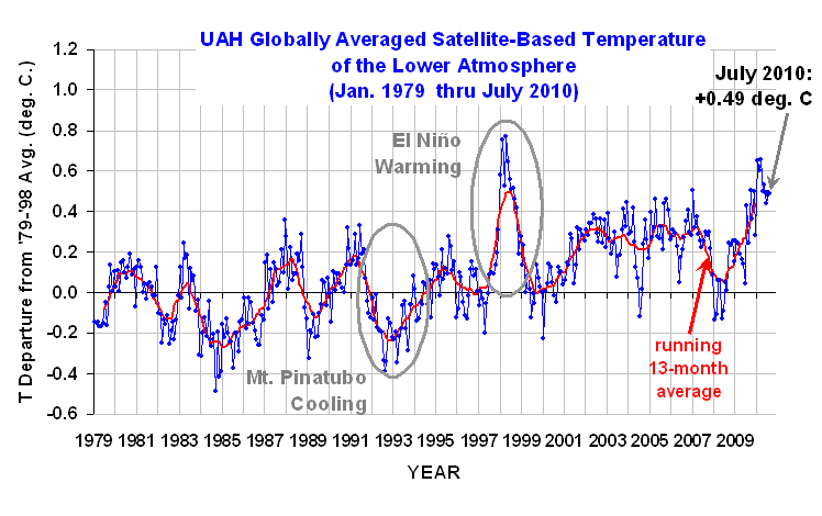
We're part way into the year, and several news stories report either that 2010 is going to be the hottest year ever, or the last 12 months is the hottest year ever. Is this premature? Is it significant? That's something not covered by the stories. Let's take a closer look.
In 2008 and 2009 when La Niña was bringing in temperature similar to cool years in the 1970s, that was dismissed as just weather and that you need decades of data to show climate change. Here we are, just a year or too later and part of a year is appears to be good enough to sound the alarm about climate change again.
It's a familiar pattern. Personally, given the durations of various events, there are good reasons to look at time periods that are multiples of the cycle or very short parts of the cycle. That's done to suppress their effects on projections of future conditions. Some of these cycles and their periods are:
How hot was summer 2010? My unofficial result from unofficial data from the Concord NH National Weather Service station is an average temperature of 69.4°F. That's the hottest summer (June, July, and August) on record, and those go back to 1895, and it beats the old record from 1949 and 1955 by a substantial margin, 1.4°.
Alarming? Well, no. Summer 2009 was only 63.8°F, the 20th coldest summer in the record. While the northeast had a hot summer, the northwest had a cool summer with complaints about chilly weather reaching down the coast. to San Diego. The continental United States is only 3% of the Earth's surface, what happens in New Hampshire has only a very small impact on global averages.
Ah, but the weather is getting more variable, right? Perhaps. I haven't studied that closely, but I noticed the following data from the early part of New Hampshire's summer temperature record. The accompanying graph includes two warm peaks from the PDO cycle, a bigger climate driver than the CO2 changes over the same period.
Year Temp Rank 1895 66.9 103 1896 66.6 97 1897 64.0 25 1898 66.9 103 1899 65.6 74 1900 66.9 103 1901 67.2 110 1902 62.1 3 1903 61.1 1 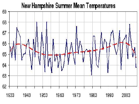
I've seen few, if any, rigorous comparisons of weather variability over time, pretty much everything I've heard has been anecdotal.
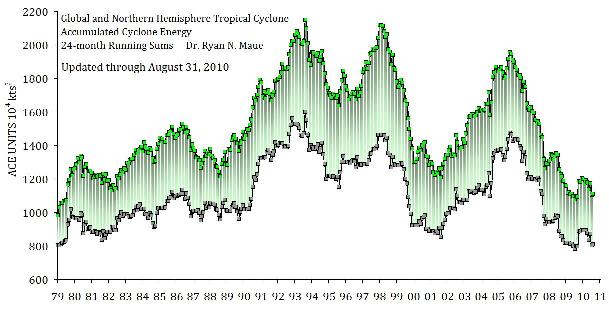
There are lots more hurricanes, right?
Well, sort of. In 1995 the Atlantic entered a period of much more activity. This wasn't due to global warming, but a shift in an Atlantic ocean wind and water pattern called the AMO. The last active period was in the 1940s to 1960s and included three major hurricanes in New England. We've been very lucky we've had not hurricanes of note yet in this period.
Globally, tropical cyclone activity is scraping along at a 30 year low, the prediction that global warming means more tropical cyclones isn't panning out.
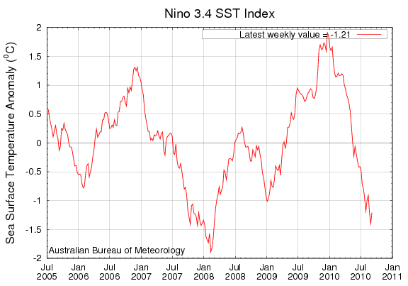
Climate is always changing, and changes on almost any time period you might examine. We've reached the end of a warming period due to the PDO and cooling began in 2008. It was interrupted by the recent El Niño, and that is giving way directly to La Niña. Atmospheric temperatures tend to lag La Niña by a few months, and we're ready to see cooling set it. This may be the last good time to convince people that global warming is still going on, as some of the seasonal forecasts are expecting a lot of cold weather. If I were you, I'd split an extra cord of wood for this winter.
Contact Ric Werme or return to his home page.
Written 2010 Sep 9, last updated 2010 Sep 9.