Lewis, Clark, and Transamerica a/k/a "Mom's Fiftieth Birthday
I-don't-want-to-grow-up Bicycle Ride Across America"
Western Oregon
This is one segment chronicling my family's bicycle tour through
the northwest, and Paula's continuation beyond Montana. If you came here
via a Web search, you might want to back up to the
index page to start with the overview.
 |
July 8th
After the dreadful ride on Rt. 30 to start out the trip, I've
been paying attention to places that say "This is Oregon". Immediately
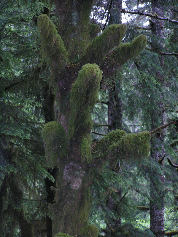
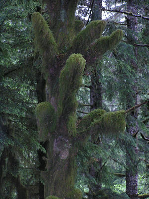
after leaving Neskowin we turned up Slab Creek Road and quickly got into a
coastal rain forest environment (with heavy drizzle) and trees laden with moss, rocks
covered with moss, and pretty much everything except the pavement covered with
moss. Well, moss on the shoulder too. It climbed 750 feet at a "steep grade"
according the state bike map. Need to come back and spend a day there. At the
bottom of the hill was the town of Otis, not much more than post office and
restaurant. Wonderful little restaurant, great bread. Also worth a return
visit!
|
The rest of the day was up another 750' hill, most of it along a river, to
get inland. We found a new fruit stand run by a enthusiastic woman who had only
recently heard about Adventure Cycling and that she was on the route. We stayed
at a RV park in Grand Ronde where the tenting area is shared with the dog walk
area. There are a lot of RV parks, they all have so-so accomodations for
bicycles, but they're pretty inexpensive and have good showers.
July 9th
The state bike map only showed one moderate climb, but I think there
were a couple. Inland is a lot warmer, and the bigger climb was very slow.
Most of the afternoon was on flattish roads, more cherries at a farmstand next
to the orchard, crossing a road I biked on 29 years ago, a flat tire, and
then a south turn to Monmouth on a bike lane that is detached from the main
road. I dashed ahead to try to get to a bike store and get a new inner tube
as the flat was next to the valve stem and not repairable, but I found the owner
was on vacation and the store closed. Sigh. We stayed in a motel in town.
July 10th
Today was pretty much all south in the Willamette valley, home to
some 70% of Oregonians (Portland, Salem, and Eugene are the biggest cities in
the valley and the state). We detoured into Corvallis to find an orthodontist
to repair a popped wire on Hannah's braces and went into the center of town
for lunch, that new inner tube, and groceries. There are several good bike shops in
the center of town, including one that sells a lot of recumbants. Paula has
long been interested in a recumbant bike, but most of that activity is on the
west coast and there are few chances to ride or compare them in the northeast.
We met a cyclist heading to the coast from Kansas too. All in all, enough
distractions to delay us a bit more than we wanted, but these are the sorts
of distractions we're looking for anyway.
 |
Outside of town the route got us off Rt 34 quickly and on to Peoria Rd
which parallels the Willamette and goes through a grain growing
region that is being harvested and the straw bailed. It was really our
first decent stretch of light traffic on a flat
road. We stopped for a bit at an odd county roadside stop that kind of had
two pieces - the north half had no parking but a gap in a rail fence wide
enough for bicycles, a couple picnic tables, and pit toilets. The southern
half was kind of a duplicate but designed for cars. In between was a mound
of dirt with a pipe that kids could crawl through, so you really couldn't
see one half from the other. There was no "No Camping" sign, but it was early
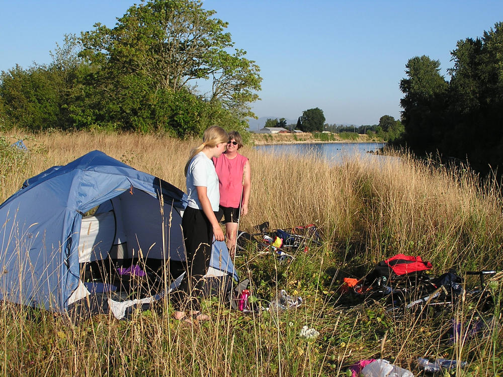
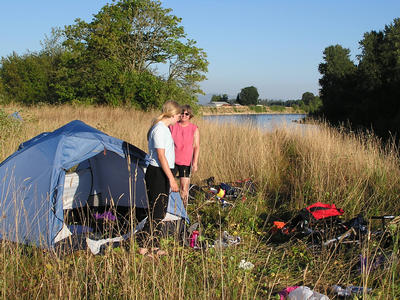
enough to press on anyway and we wound up camping off a side road next to
the Willamette. The river bank was a 15' cliff of old sediment and rocks, I
was the only one who made it down to the river for wash water. Should've
gone swimming, but the current was a bit strong. Our camp site was in grass
that had gone to seed, we're still picking out seeds from our socks!
|
July 11th
Pressing on we stopped in Harrisburg and had breakfast at a restaurant
that is the only one so far to give me a meal bigger than I could eat (all
the local patrons were overweight) and later met up with a father/son team
heading west outside of Coburg. We detoured into Eugene to find some white
gas, which turned out to be more difficult than expected. A lot of companies
now use butane or propane. We found a WalMart, bought a gallon of Coleman
fuel, used half of it to fill our fuel bottles, and gave the rest to the service
counter.
Just east of Eugene is Springfield. We passed a big factory that makes
Kingsford charcoal briquets. I got the sense from the signage that they have
other plants too, we'll have to check back east to see where those briquets
come from. The route took us on a quiet road that parallels busy Rt 126.
Luke, a solo cyclist with a trailer passed us but we caught up with him at a restaurant
in Walterville and had a good chat. He also had taken the Lewis and
Clark road and hit the gravel with enough speed to flatten both tires. Various
problems with his repairs lead to three more, and then he had another due to
a staple, so I guess we can't complain! He headed beyond us and we camped on
some unposted land on the other side of the McKenzie river just downstream of
what I first thought was a power dam, but was possibly a sewage treatment plant.
No problem - the river flow was enough to keep things dilute.
 |
July 12th
This day was spent heading upstream and uphill. No serious climbs,
and the river is big enough to keep the overall grade pretty easy. At a
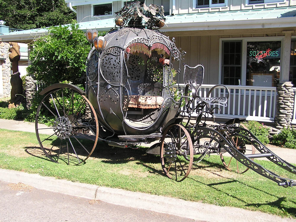
stop in the town store at Vida, we ran into an elderly lady and chatted with her
for quite a while and then more at a sculpture gallery across the road. We
have a photo of a pumpkin carriage in front of the gallery. A ways later Paula
stopped at a store. I got out my wallet and was looking forward to a popsicle
as I walked inside. No popsicles - Paula had found a quilting store! We made
it from there without further incident to McKenzie Bridge, the last bit of
civilization before beginning the serious climb to the pass.
|
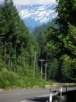 |
I expected to see snow while crossing the Cascades, but I wasn't sure if we would
pass some next to the road. I kept an eye out for the first glimpse of snow, and found it in a opening in the woods looking toward the
Sisters volcano complex. While several mountains had snow, there was none
right at road level.
|
Being Saturday, and that the Sister's quilt festival was in full swing,
Paula had called ahead to an Inn and had reserved one of four teepees on the
river. While setting up camp, Dana, another solo cyclist came in while Paula was in the
shower. She was from Portland Maine and taking time between jobs for
exploring the northwest. The teepees were plenty big, so I invited her in
for the night. Very nice person, very easy person to share the camp with.
She had spent a few days riding with Luke. Bicycle tourers tend to learn
about each other from other cyclists and local businesses. Hannah finds that
a little creepy, but it's an interesting grapevine.
We cooked dinner and had enough for Dana instead of going to the restaurant.
July 13th
Clouds moved in overnight and light rain started soon before sunrise.
I've been completely unimpressed with the quality of forecasts I've seen on
TV, read in the newspapers, or gauged on my own. However, the early morning
sky seemed pretty flat, meaning stratus clouds, meaning warm front and maybe
an extended period of rain. The weather map the day before showed a cold
front moving through our area around noon the day before, but I hadn't seen
any trace of it. Fortunately, the clouds took on a more lumpy, cumulus
appearance and began to break up before we hit the road, so it was the cold
front arriving late.
We were going to eat at the Inn's restaurant but discovered that
it didn't open until 9:30 for
brunch. Dana walked over to the store in town for eggs, but the store wasn't
open either. She made some Ramen noodles while we started packing. Later
Hannah went to the now open store and got eggs for our breakfast for today and
tomorrow.
We had been playing phone tag with my brother Doug. His last message was to
volunteer to take our panniers over the pass, but we couldn't call back on the
cell phone and Dana was on the pay phone, and Paula wasn't about to collapse
half way up the road without a tent. So we just took off. The day before we
had climbed to about 1,500 feet and had another 4,000 feet to go. There are
a couple primitive campgrounds on the way up, and I was hoping to get at least
halfway up today, hopefully to the second campground as the first was only
about a third of the road distance to the pass. We only made it to the first,
but I was very relieved to find it was a little more than 2,000 feet up and into
the switchbacks after leaving the river. That confirmed that the Adventure
Cycling map showed the grade leveling out a few miles before the pass and that
the switchbacks to that point suggested the current grade would continue.
A nearby stream provided plenty of water (we have a water filter for Giardia).
The campground was too primitive for most people, so there were only four other
vehicles there.
 |
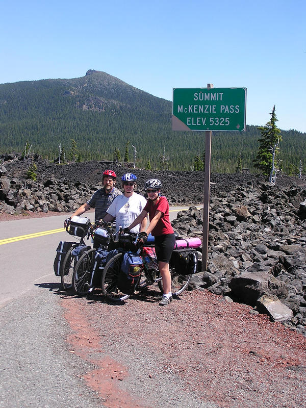
The road we were on, Rt. 242, was south of the obvious route, but Doug
strongly recommended it as Rt 126/US Rt. 20 had all the truck traffic.
The switchbacks are impossible for long vehicles, and pretty miserable for
anything else too except for bicycles heading uphill. All in all, I was
pretty content and confident we'd easily make the top the next day.
|
July 14th
We had eggs and hashbrowns for breakfast and got off to a little
later stop than I wanted. A couple hours later we stopped for bowls of
granola and returned to the grind. By now altitude was affecting Paula and
Hannah and I encouraged them to breath in a way I figured out before with
deep inhale, hold for a second and then a quick refill. We reached the top
of the switchbacks, had a short slight downhill, an only one or two more
steepish uphill stretches to the pass.
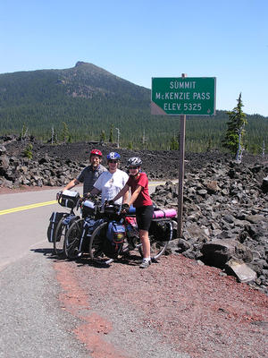 |
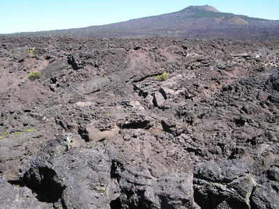
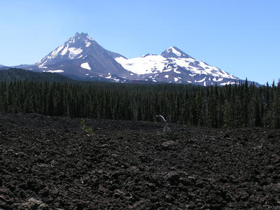
Just before the campground the day before was a trailhead that went for a
mile or so around a lava flow. I nearly went back to walk it, but I knew there
were more ahead. One roadside stop was next to a flow and climbing up fifteen
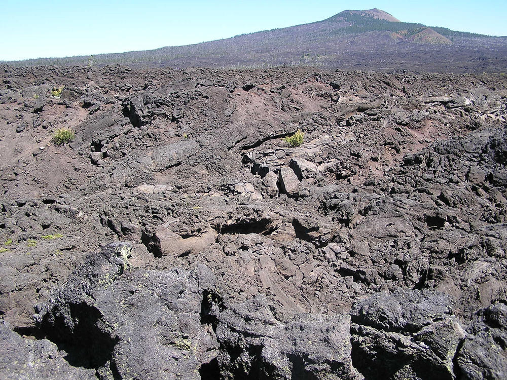
feet showed a big expanse. At the pass is an "observatory" built out of
volcanic rock and with pointers to the various volcanoes and buttes in the
area. The lava flow all round the area was the thick sort like what you
may have seen in pictures of active flows in Iceland, kind of an advancing
wall with rocks rolling down the leading adge as it slowly advances. The
eruptions dated from only 1500-1700 years ago and with very little ashfall,
plants have neither the foothold nor water they need to recolonize. There
are scattered trees, but a substantial percentage were dead, I suspect from
a bad drought year some time ago.
Our view was only slightly impeded by a forest fire in the area, blocking
part of our view of Mt. Jefferson and all of distant Mt. Hood just to the
right. We had seen signs before warning of delays and closures on the other
pass, so we were concerned we might have more trouble.
|
From there it was an easy ride down to Sisters with only a couple sharp
turns. In town, a fruit stand was the first order of business, and the ice
cream shop across the street the second. Paula went out in search of postcards
to tell fellow quilters that she had missed the quilt festival and to find
quilt stores. Hannah went in search of other stores, and I tried to call
Doug to say we finally made it across the pass but only got his answering
machine.
After poking through a few stores myself, we got back together and left
bikes in a small park. Paula and Hannah went off again, and I just stayed with
the bikes. While gazing around, I saw someone who looked a lot like my
sister walk around a building and come my way. She came up and said "Hi!" and
I replied that I should be surprised but somehow wasn't. Chris lives in Berkeley
and Paula Emailed her a note that she had to come for the quilt show. She
had - and was planning to stay for a couple weeks. Doug soon found me too and
commented that he got the phone message minutes after I left it when they
returned from a kayak trip. He and Chris
figured it couldn't be too hard to find us in town or on the road, so they
just came. And found us readily.
So that gave us a free ride to Bend and a chance to catch up with the
Tour de France, and especially the Beloki crash/Armstrong recovery that
happened that day. Everyone had made it to the quilt show. Apparently
thousands of quilts hanging from almost everywhere and of all qualities and
styles. Paula will have to come back another year.
July 15th
We watched the Tour stage to Marseille, then went kayaking
at Crane Prairie Lake on the other side of Mt. Bachelor. The smoke is
more pronounced today. I think the fire was 100% contained a day or two ago,
but there's still a lot burning inside the containment zone. The heavier
smoke should be just due to the winds.
July 16th
Whew! Caught up, except for editing, updating my page, etc.
We'll work on bikes, panniers, and pare down the load we're carrying (Doug and
Cheryl made a trip to France and Spain last year with an absolute minimum of
gear, I guess I'll save comments about our load for my page).

 |
July 18th
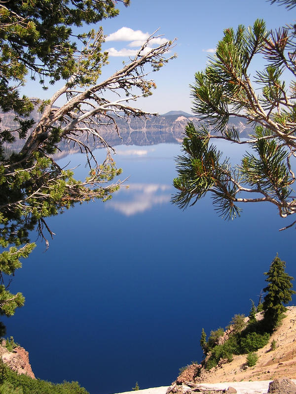
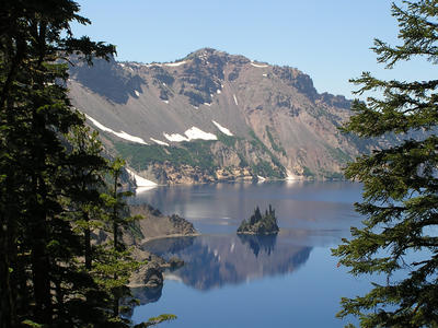
Well, for those of you who are wondering if we're back on the road, we're not. We've spent a leisurely week in Bend kayaking, biking, visiting Crater Lake today, and most importantly, eating. For those of you who may not know, Doug and Cheryl's (Ric's brother and his wife) or Chris and Mike's (his sister and her husband) is the best place to be in America during the Tour de France, due to Cheryl's, Doug's, and Chris's joint collaboration on the "Tour de France" race, food, and wine guide, which features menus and wines from each region the tour visits as it progresses during the month. While we started out the first night with pizza,
[that's because the stage ended in Gap, and all Doug found there for restaurants
were three pizzerias - Ric]
the menus have been somewhat better than that most nights, and the wine is excellent. Some of our better items have included Salmon Rillettes, an artichoke and tomato salad, like a tuna salad, and "Steak with Shallots in Red Wine Sauce in the Style of Albi." We'll finish off our visit with Toulouse-style cassoulet tomorrow before heading out Sunday morning. We probably won't make any headway at all after all this wonderful food this week, but such are the sacrifices of the long distance travelers. If we finish the tour, we'll never make it halfway across America, let alone all the way across. So, look for updates sometime next week. We'll be working off the extra calories in the meantime.
- Paula
|
We finally get back on the road on the 21st and head east into the high
desert. The next page in the chronology covers the rest
of Oregon.
Other links:
index page and overview
Paula's page
Ric's page
Hannah's page