
This is one segment chronicling my family's bicycle tour through the northwest, and Paula's continuation beyond Montana. If you came here via a Web search, you might want to back up to the index page to start with the overview.
July 21st
Finally, we leave Bend. It was tempting to stay longer, but we are here for
the biking.
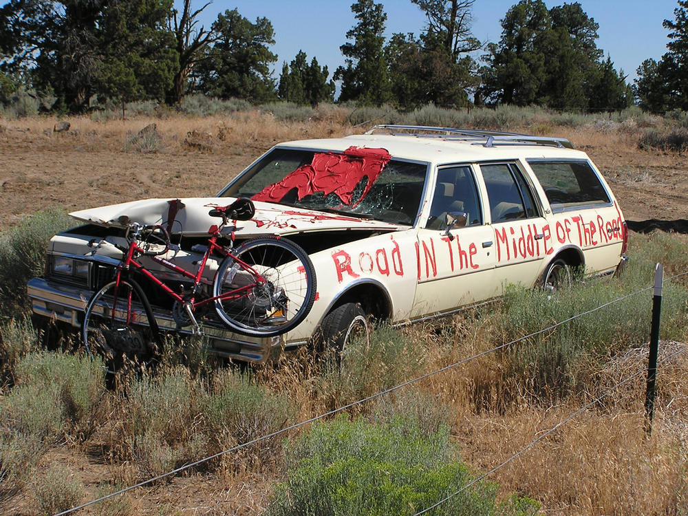 |
Doug and his friend Bill lead the ride out, taking us on the road to
Alfalfa and one of the smoothest roads around Bend. Some ranchers in
the area don't appreciate the influx of cyclists on their road and
don't give them much passing room. One put an old station wagon by
the side of his property, attached a mangled bike to the grille,
painted a big red splotch on the windshield and wrote "I Road IN The
Middle of The Road" on the side. The cyclists in the area want to
replace the bike with a pair of oars. :-)
Alfalfa hosts a nice country store that looks at cyclists as a revenue boost. The store has picnic tables and shaded areas and often gets day riders both coming and going. One of the other patrons chatted with us and sounded pretty envious of our ride ahead. |
 Beyond Alfalfa the irrigated fields quickly give way to hillier terrain
with tounges of old lava frozen in place. Paula broke a chain in
an awkward shift, and Doug volunteered to do the dirty job of fixing it.
I was sort of interested in using Paula's chain tool, part of a Topeak Alien
toolset, but not so interested to discourage Doug! The road ended at Rt 27
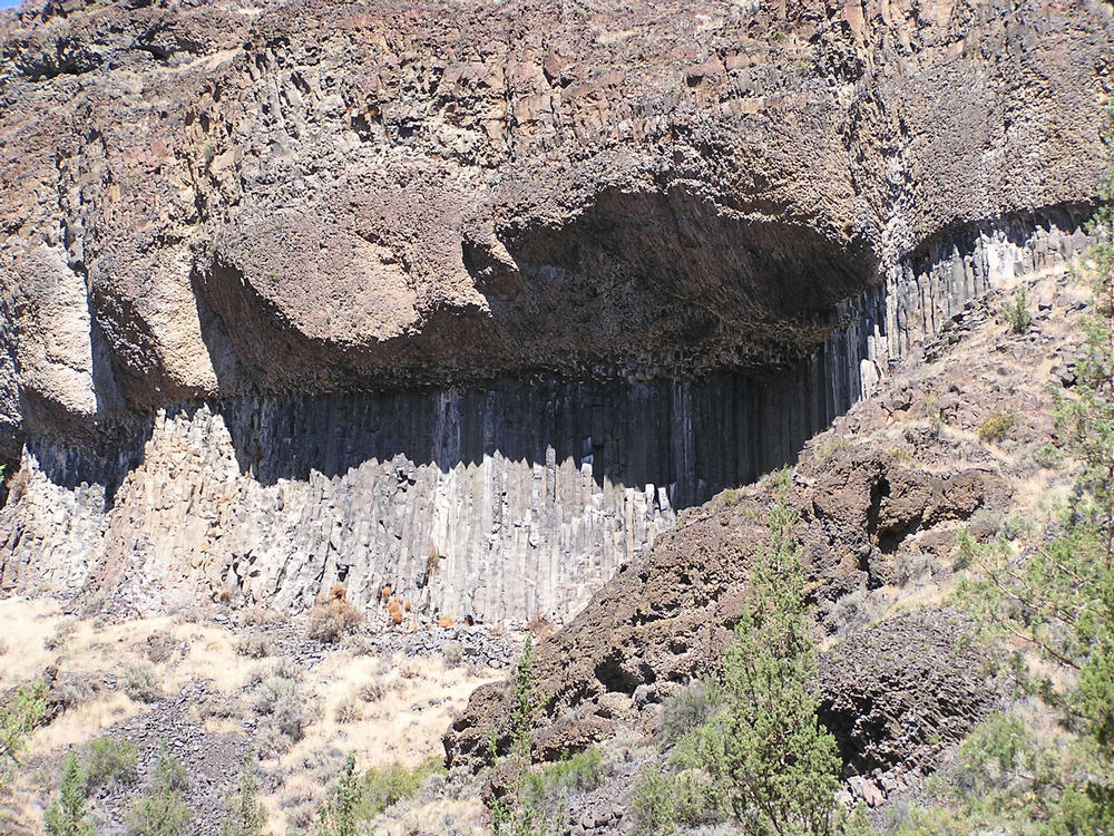
near the dam end of the Prineville Reservoir. The river drains through a
canyon of volcanic rocks with good displays of columnar basalts interleaved
with layers of ash. Some of the ash is welded together so firmly that it overhangs the
basalt columns. I was wondering if the canyon was cut since the last ice age,
but concluded the next day way too much material was eroded for that. Still,
from the numerous dents in the road (and the rocks I rolled out of the road)
it's clear erosion is still ongoing.
Beyond Alfalfa the irrigated fields quickly give way to hillier terrain
with tounges of old lava frozen in place. Paula broke a chain in
an awkward shift, and Doug volunteered to do the dirty job of fixing it.
I was sort of interested in using Paula's chain tool, part of a Topeak Alien
toolset, but not so interested to discourage Doug! The road ended at Rt 27
near the dam end of the Prineville Reservoir. The river drains through a
canyon of volcanic rocks with good displays of columnar basalts interleaved
with layers of ash. Some of the ash is welded together so firmly that it overhangs the
basalt columns. I was wondering if the canyon was cut since the last ice age,
but concluded the next day way too much material was eroded for that. Still,
from the numerous dents in the road (and the rocks I rolled out of the road)
it's clear erosion is still ongoing.
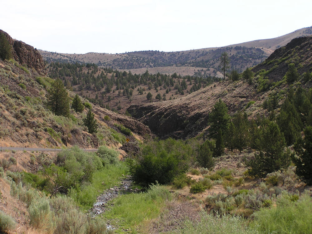
There are several small campgrounds along the river, and we picked one where the canyon was beginning to open up. There was a path across from the entrance that goes up to the "Devil's Postpile," but I went a little way and decided to pass on the rest. The river water was quite silty and clogged our water filter every few liters, but no big problem. For the most part the campgrounds are visited by anglers looking for trout in the cold water released from the bottom of the reservoir.
July 22nd
As we continued through the canyon, I concluded we had stayed at just about
the best of the little campgrounds. The canyon gradually widens and the
road flattens. The land is a series of small ranches using the river water
for irrigation. The only interesting one had some llamas in an area near
the road.
At Prineville (2864') we had a second breakfast and rejoined the TransAmerica trail on US Rt. 26. The road traffic gradually lessened over the day while we embarked on a long climb to Ochoco Pass (4722'). At the Ochoco reservoir is a park and campground. Being an agricultural resource instead of drinking water supply, swimming was okay and quite welcome. No point in putting on a bathing suit as bicycling clothes dry (all too) quickly back on the road.
After the pass, downhill brought us to a hot 500' climb to Mitchell. At Cannon's service station, Ed Cannon welcomed us to "300 feet from Hell," to which I replied "That's a relief, I thought we were already there!" His thermometers read about 100 degrees, it was probably just as well that I didn't know that before.
Mitchell (2777') is one of those towns that is barely hanging on. Still, there are nice pockets and we spent the night at one, the Oregon Hotel. The proprieter welcomed us to "the middle of nowhere." Despite the lack of air conditioning, the inside was reasonably cool until the sun hit our corner room on two sides, but sleeping was cool enough. The hotel was the first I've stayed at in years that had common baths. There were few other people staying there, so no conflicts.
July 23rd
We got up early and cooked breakfast in the park before the restaurant opened
to get ahead of some of the
expected heat. The climb to Mitchell continued
with a climb to Keye's Creek Summit (4372').
Along the way, someone had painted notes in the breakdown lane for other
cyclists ("Keep pedaling," "Many have tried, few have reached the top",
"You call this a hill?", and "U R Awesome") which helped provide encouragement.
The downhill quickly dropped us into the day's heat. I was riding ahead when
Hannah hit a rock and got a flat tire. Paula flagged down someone to tell me
I needed to go back. I had stopped to let then catch up, but had to turn
around and climb a very hot 250' to get back to them. Sigh.
 The road goes through Picture Canyon and passes Rt 19 near
the John Day Fossil Beds
National Monument.
We picked up the John Day River (I'm still not sure who this John Day fella was)
and I promptly dunked my jersey in it. It's remarkable how much stronger one
feels cycling when your body isn't working hard just to keep cool. An easy climb
brought us to Dayville where we discovered Dayville Mercantile,
the best small store we've found to date. It's run by an avid cyclist so he's
stocked it with few bike things - all good stuff and I'm sure a welcome
surprise to other cyclists. I picked up a nice little sunglass mounted
rear view mirror. Steve Cookinham, the owner, worked for MCI in his last past life and
has roots going back to Teletype repair. So I had a good time chatting
with him while Paula and Hannah went to the other end of town to check
out a hostel and the town park.
The road goes through Picture Canyon and passes Rt 19 near
the John Day Fossil Beds
National Monument.
We picked up the John Day River (I'm still not sure who this John Day fella was)
and I promptly dunked my jersey in it. It's remarkable how much stronger one
feels cycling when your body isn't working hard just to keep cool. An easy climb
brought us to Dayville where we discovered Dayville Mercantile,
the best small store we've found to date. It's run by an avid cyclist so he's
stocked it with few bike things - all good stuff and I'm sure a welcome
surprise to other cyclists. I picked up a nice little sunglass mounted
rear view mirror. Steve Cookinham, the owner, worked for MCI in his last past life and
has roots going back to Teletype repair. So I had a good time chatting
with him while Paula and Hannah went to the other end of town to check
out a hostel and the town park.
Today is about as hot as yesterday and we collapsed for a couple hours at the park, but eventually decided to press on to Mount Vernon. We found a tired motel that had stuffy rooms, but also an air conditioner. We all enjoyed a cool night.
Total milage for the day was about 60, the longest so far. Pretty good given the heat and all.
July 24th
Today is a lot cooler. Still pretty warm, but not bad riding and no major
hills until a really big one at the end of the day. We stopped in the town
of John Day (3083'), big enough to host a real grocery store, bowling alley, and
defunct outdoor movie theater. They seem to have quite an agenda of events,
with an antique motorcycle rally underway and solar energy gathering in a couple
days. The temperature is in the upper 80s, yesterday afternoon was near
110.
Prairie City is a smaller town, sort of touristy, where we had lunch, shopped, and ice cream. Then the big climb to Dixie Summit (5279'). Not too steep a climb, but Hannah had trouble digesting ice cream and hill climbing at the same time. Fortunately, that problem clears up fairly quickly, and we made it to the top and then to a nearby forest service campground a few minutes later. A couple rain "events" got us to put rain flies on the tents, but there was only a trace of rain total. I some some stars through the thinning clouds and figured that was it for the night.
July 25th
Today started with the promise of some sun, but also enough clouds to help keep
things cool for the two main climbs, each about 1000'.
After a quick downhill to Austin Jct, we headed up to Tipton Summit
(5124') with comfortable temperatures. I picked up some water at a roadside
spring, the first I've seen on the trip. The climb was uneventful and the
ride down quick. We followed a river downstream for several miles going past
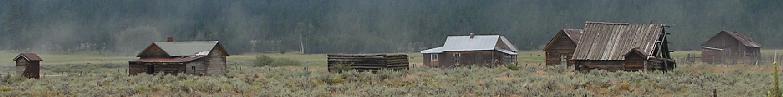
Whitney, a town abandoned in the 1950s after the railroad shut down. We then
left the river for the other big climb of the day to Larch Summit (5082') and stopped for lunch just
a bit of the way up. Sun changed to clouds during lunch and part way up the
hill a thunderstorm began forcing a stop for an hour or so. Waiting out
rain with nothing to do is boring.... [Hey, Doug, you told Paula it wasn't
going to rain for the next five weeks! I'm beginning to think this is the
land of broken weather forecasts - I think the official forecast said only a
20% chance of rain.] A second cell came through too, but when
things began to lighten we figured there wasn't much point waiting longer and
got rolling. The rain stopped before we got to the top and ride down on
damp roads wasn't very wet.
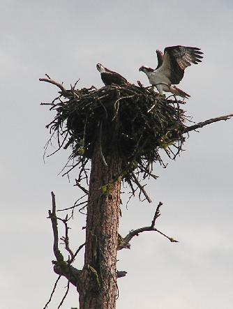 That brought us near Sumpter, part of the old Sumpter valley logging
railroad that we've been paralleling, I think. We picked up a river that
goes through an old gold mining area that mined by dredging and ends at the
Phillips Reservoir. The area is a wildlife refuge with eagles, ospreys,
Sandhill Cranes, etc. and the road follows the reservoir but well away from
it. The reservoir drains into the Powder River which is white water and
cuts another canyon. A headwind kept things from being a fast ride. The
canyon runs for several miles then turns north and opens up into a broad valley
interrupted by hills at the northern end. Through that it's a few more miles to
Baker City. Hannah picked up a staple near the end of the canyon and I
noticed her rear tire going flat early in the valley. She put on a tube I
patched before, but it didn't hold air, but I had a second spare that was fine.
Meanwhile, another thunderstorm was gathering to the west, but was also heading
north and served mainly to block the evening sun.
That brought us near Sumpter, part of the old Sumpter valley logging
railroad that we've been paralleling, I think. We picked up a river that
goes through an old gold mining area that mined by dredging and ends at the
Phillips Reservoir. The area is a wildlife refuge with eagles, ospreys,
Sandhill Cranes, etc. and the road follows the reservoir but well away from
it. The reservoir drains into the Powder River which is white water and
cuts another canyon. A headwind kept things from being a fast ride. The
canyon runs for several miles then turns north and opens up into a broad valley
interrupted by hills at the northern end. Through that it's a few more miles to
Baker City. Hannah picked up a staple near the end of the canyon and I
noticed her rear tire going flat early in the valley. She put on a tube I
patched before, but it didn't hold air, but I had a second spare that was fine.
Meanwhile, another thunderstorm was gathering to the west, but was also heading
north and served mainly to block the evening sun.
Once in Baker City, we headed for the Baer House B&B run by the same folks who have the Dayville Mercantile. Nice place, well decorated by his wife who was visiting relatives. Pretty good deal for Steve - he sells a bottle of Gatorade in Dayville, then gets more business two days later!
July 26th
Baker City looks like an interesting
place, so we declared today a rest day to explore. I think I'll call it "The
somewhere in the middle of nowhere." The library is across the street,
hence this update.
July 27th
[Notes - 1) This keyboard has an unreliable space key, 2) I'm going to try
switching to present tense for this update.]
Between WWW updates, talking to Steve, and various other whatnot, we used up yesterday pretty quickly. We're back on the road today, the first order of business was to climb Flagstaff Hill, cross the route of the old Oregon Trail, and then climb another hill to the Oregon Trail Interpretive Center. I walked, Hannah and Paula rode. I caught up to them and walked their bikes the rest of the way....
 The Interpretive Center is pretty interesting and we spent more time there
in the precious morning coolish weather than we should have. [Note - add a
link.] Paved roads, bicycles, services along the way - we have it easy!
As we left, I filled a four liter water bottle as there isn't much
before Richland except a substantial hill (2589'). In fact, about the only
thing of note along they way is a big "Cold pop" sign with a hand painted
Pepsi logo on top of a rather tired house. On the porch is a Pepsi machine
that does sell cold pop (50 cents per can, a bargain). This must be the
oasis that another cyclist mentioned in Mitchell! A couple of bicyclists
we met today told us of stopping at a store just before a downburst hit and
then being forced to spend the night because mudslides blocked the road.
The Interpretive Center is pretty interesting and we spent more time there
in the precious morning coolish weather than we should have. [Note - add a
link.] Paved roads, bicycles, services along the way - we have it easy!
As we left, I filled a four liter water bottle as there isn't much
before Richland except a substantial hill (2589'). In fact, about the only
thing of note along they way is a big "Cold pop" sign with a hand painted
Pepsi logo on top of a rather tired house. On the porch is a Pepsi machine
that does sell cold pop (50 cents per can, a bargain). This must be the
oasis that another cyclist mentioned in Mitchell! A couple of bicyclists
we met today told us of stopping at a store just before a downburst hit and
then being forced to spend the night because mudslides blocked the road.
As we climb another small hill into Richland, Paula is dragging pretty badly. It's late enough to be worth stopping instead of pressing on to Halfway like Steve recommended, and we camp in the big town park. Pretty nice spot, actually.
July 28th
After breakfast in town, it's time for the main event of the day, a long,
steep climb up to 3653'. I measured one half mile stretch at 7%, tough with
our loads and the exposed sunny area. On the other side, it's a good ride
down into the town of Halfway, which may be named half.com now as there's a
sign that claims it's the first .com town. I have no idea what it's half way
to, from, or between, but the people are friendly. Paula feels a lot stronger
heading out of town (or I'm dragging a bit), and I have trouble catching up
after a Gatorade and soak the bike jersey in the river stop. We pick up Pine Creek
and follow that downhill brushing by the southernmost tip of Hells Canyon
National Recreation Area and the deepest gorge in the US. It's nowhere
near as wide as the Grand Canyon, but I don't know how deep it is. Not
much more than the Grand Canyon, I'm sure. Along the way we stop for half an hour
waiting with other traffic that is being led by a Pilot car past the
mudslide areas. It's clear the storm was very narrow, but it must have dropped
a lot of water. The Creek is muddy below to where it joins the Snake River.
Just after the slide area we stop at an RV park that looks like it's full of fulltime users. The tenting area doesn't have a table, the bathroom sink is clogged, and all this for only $24! At least the water is good well water and not affected by the slide.
It turns out that many of the people there work for Idaho Power and working on a new powerline from dam just down the road - and in Idaho. About time we reach another state!
Other links: