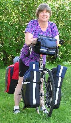
 I did a lot of preparation that most cross
country cyclists don't do. E. g., I made the panniers for the trip
and a whole lot more!
I did a lot of preparation that most cross
country cyclists don't do. E. g., I made the panniers for the trip
and a whole lot more!
I did a lot of preparation that most cross
country cyclists don't do. E. g., I made the panniers for the trip
and a whole lot more!
I had a hard time finding information on planning a major physical challenge like a cross country trip on the web for people with Fibromyalgia. I wrote a separate page with background on my diagnosis, the history of the fibromyalgia, the physical challenges of getting in shape, and how I control my Fibromyalgia.
On June 17 - 18, Hannah and I tested the equipment and our fitness level by taking a two day trip to Milford, NH from Boscawen. Having biked all spring, we weren't expecting a lot of trouble. We were wrong. Our start day turned out to be bright and sunny, although not especially hot. We did get a later start than anticipated. I tossed in some equipment we did NOT need to show our friends when we got there, and some dinner and breakfast in case we didn't make it in one day. That was the smartest thing we did.
The trip out of Concord was very challenging. To avoid a nasty hill on
the way to Route 202 West, we paralleled Penacook Lake, then took Route 202
until just before I-89, and headed South on Jewett Road. The hill getting out
of what I call the "Concord Bowl" up to the farm was a killer.
 The sun was as
high as it could get, and Hannah and I more than once stopped, bent over the
handle bars, too out of breath to even speak to one another. We walked the
bikes the last 40 yards or so. I wondered how we were ever going to make it
out of New Boston and Weare on Route 77. We had to stop for water by going up
to a house and knocking on the door. We met a very nice lady who thought we
didn't have water bottles, and offered us her husband's! While her dog barked
protectively, I followed her into her house and we filled our own bottles,
told her a bit of our planned trip, and continued on.
The sun was as
high as it could get, and Hannah and I more than once stopped, bent over the
handle bars, too out of breath to even speak to one another. We walked the
bikes the last 40 yards or so. I wondered how we were ever going to make it
out of New Boston and Weare on Route 77. We had to stop for water by going up
to a house and knocking on the door. We met a very nice lady who thought we
didn't have water bottles, and offered us her husband's! While her dog barked
protectively, I followed her into her house and we filled our own bottles,
told her a bit of our planned trip, and continued on.
Hannah had a cold, and she was totally whipped by the time we reached Weare, about 24 miles from home. I stopped at town hall and asked about come camp grounds I recalled on the way to Milford. We were directed instead down Route 114 toward Manchester a couple of miles to Cold Springs. The hill out of Weare was long and slow, but the grade was easier than expected, and as tired as we were, it wasn't near the challenge I expected. The campground was the fanciest *I* had ever been in, and I worked in a pretty fancy camp ground in college for a summer. The bathrooms were so clean, it appeared you could eat off the floors. Cold Springs: http://www.coldspringscampresort.com/
One thing that tickled me was remembering our portable screen porch for our solar house in Mont Vernon when Hannah was a baby. Every spring we would set it up, and take it down in the fall. We used to spend hot summer nights sleeping on the futon on the porch, enjoying the night sounds, including the regular howling of coyotes. I had never seen a portable porch like it until we got to the camp ground. There were many vacation motor homes permanently set up in it. There were also five of those porches attached to motor homes between our camp site and the bathroom! NOW I know where the former house owner got the porch screens!
We had a leisurely evening. I showed Hannah how to set up the tent, work the camp stove, how to wash her bike clothes during her shower - I made a little "wash bucket" for soaking sweat-encrusted bike clothes out of nylon. I started one of my "e-books" I had downloaded just before bed, and we both slept pretty well.
The following morning, after taking longer than I wanted to pack up, we had an easier ride than expected back to Route 77, and proceeding in threatening rain toward New Boston. Just as we were coming to the general store, a woman walked past us with three pizzas - 10:45 in the morning, and I said to Hannah, "Did you see THAT?" I wandered into the store once the bikes were secured on the porch of the store, and paid for two slices, grabbed some carrots, a candy bar, and went to the porch where I could sit and eat it. Hannah went in to pick out her pizza, we both wandered across the street to the library for a quick pit stop, and tackled the hill leaving New Boston. After our rest and food break, the hill was MUCH easier than expected, and we weren't uncomfortable biking until we got close to our old home at the north end of Mont Vernon. THAT hill was longer and steeper than we expected. The rain had arrived, and we slogged slowly and dripping up the hill into town. After that, we had to work our way out of town on roads I barely remembered because my intended short cut to Milford was under construction. One road that showed on the GPS receiver as going through to our short cut turned into a foot path! We decided that with wet bikes, wet shoes, and wet grass on the path to turn around and try another route. We were more tired than expected by this point as well, although it was only early afternoon. Finally, we made it across 101, and started up Savage Road toward our friend's house - uphill most of the rest of the way. We were drenched, sweating, and starting to get chilled when we got there around 2:30.
I told my friend Joy that it was really fun to arrive, and while parking our dripping bikes, I heard her now full grown 17 year old son squeal from inside the house, just as he did when he was little, "They're here!" He always was excited when I took Hannah there for a day of sitting. We grabbed some honey, some maple syrup, and farm-fresh eggs for the trip home, had our visit, and Ric arrived a couple of hours later to give us a ride home.
Our average speed up hills was about 3 mph. Calculating the distance of the country, we have to get in a LOT better shape to make it all the way across. Hannah and I joked about whether or not we'll even make it to the end of the Lewis and Clark trail. But, it's STILL going to be a fun trip, whether we make it or not.
In the "things you never knew about your husband" arena, Hannah and I are BOTH laughing at Ric on occasion. As we rounded a bend to see RIGHT in front of us a cooling tower from a nuclear reactor, Ric said to Hannah, "We might be coming up on a nuclear generating plant." I said, "MIGHT? How can we NOT come up on a nuclear generating plant when it's right in front of us?"
July 7 - It's hard work making it down the coast - a lot of hard hills. My biggest problem is Hannah and Ric "tailgaiting," so I when I go to bring the bike closer to the side of the road, there is a bicycle tire between my back wheel and the edge of the road. They both think I'm a witch for yelling at them for it, but I haven't seen a bicycle mirror yet for the right side of the bike. Other than that, the Oregon coast is all it claims to be - gorgeous views, wonderful beaches, and a lot of it undeveloped. Hannah would have liked to stay longer in Seaside - it's a typical beach resort area wtih lots of stuff for kids to do, but we had to press on. We just passed the second "Haystack Rock," so it's unclear which one claims to be the "real" Haystack Rock. The one further north was more impressive, but the beach area around it was over developed, so it was hard to get a pic without getting utility lines in it. The one in Pacific City isn't as spectacular, but the beach is nicer. Not that anyone goes SWIMMING in the ocean without a wet suit. It's too cold. Heading inland toward Eugene later today.
July 16 - I'm supposing everyone thought we were dead. At least one member of the family wanted to call the Oregon police just to make sure that a "family of three" wasn't killed by a semi-tractor trailer truck driving illegally on Mckenzie pass. We were just out of touch with computers for a while. Heading for the desert in a couple of days, and there may be a gap in the updates then as well. Well, I missed the quilt show, but Chris and the gang bought me a t-shirt from it - it will be shipped home on final day here, as it's cotton and useless for bike trip. It would also be dead by the time I got home if I took it along. They told me that the quilt show had just a few too many from the locals that weren't particularly great. I'm sure I'd have paid attention to better ones anyway. I was told at the quilt store on the McKenzie pass that although the quilts are only hung for a day, the event is actually a week long seminar and quilt class event at this point, so I know how to make my plans for the next time out.
Ric and Hannah have adequately described the terrain and biking, so I won't duplicate. I also said that the next update, I'll have to remember not to read Hannah's page before writing my own. I sort of feel as though there isn't much more to say. One thing that neither Ric or Hannah have commented on has been the great variety of wild flowers. I assumed we'd miss bunches because of not starting in the spring. Oregon has plenty of summer blooming wild flowers to keep the trip interesting. I've only seen one or two of them back east, so it's a fun trip from that perspective. They changed on the east side of the pass as well - it's very dry on this side, and there aren't as many, but there are some. One thing we didn't time the trip for correctly is the bunches of blackberries which aren't ripening fast enough for us to actually eat. Hopefully, we'll find some in Montana or North Dakota.
We had a few problems with the rear panniers on the way here. The basic problem was that I used various materials to stiffen the back of the panniers, and some worked better than others. Also the hook I bought from Seattle Fabrics fit MY pannier racks fine, but didn't fit over the slightly wider tubing of Ric's and Hannah's pannier racks. Doug had some great Costco plastic storage boxes with molded-in plastic gridding that was extremely stiff, so we cut it out to replace the three worst backing sheets. Doug also found a nice strip of aluminum, which he fashioned into some replacement hooks for the backs of the rear panniers. We're not quite done with installation yet, but they'll be much better when done.
I thought we had things down to the bare minimum, but Doug and Cheryl are into the absolute minimum bike touring equipment. They take only one biking outfit with them, and because they don't generally camp, they have their equipment down to two rear panniers apiece. I figure since our tour will last four months over a variety of climates, we need the stuff we have, but we're supposed to have the family inspection by the "impartial jury" tonight. On the other hand, since Doug indicated we made it over the McKenzie Pass with "boxcars" full of stuff, he said we could veto any decisions by the "jury" on what to take out. I think they intend to take out basic equipment. . . we'll see.
July 26 - Mile 736.
The panniers are working better now that they've been reengineered. Doug had the chutspah to weigh my bike and packs before we left, and weighed them in at 80 lbs, which he deemed absolutely unacceptable. I then had to confess that he did such a good job of trimming our stuff down, I decided to pack Harry Potter to finish it on the road. I've more than once regretted that decision, but he's still with me. I hope to get some reading in this afternoon on the rest day to make another major dent in it. So, I guesss we flunk "light loaded touring."
It just occurred to me that no one knew how far we actually were traveling because we weren't putting the mileage on the pages. We're on a rest day in Baker City, OR, which is less than a day's ride from our next state, Idaho. The biking has been quite difficult, with several major passes. One thing that one can't help noticing is the climate changes that occur literally just about at the top of the passes. At the top of McKenzie Pass in the Cascades, (El. 5324), the lush western forest abruptly gave way to the ponderosa pine arid desert forests. There were trees all the way to Sisters, but when we left Bend, they quickly disppeared, and we had several days of riding in mostly treeless desert. We stopped frequently for "shade breaks." Water was a big concern for several days. Even though we rode along rivers, in many places the ranchers have riparian rights for irrigation, and there is a barbed wire fence between the road and the river. We picked up a couple of extra water containers in Bend, and needed them on at least one days ride. The other climate change was at the top of Dixie Pass - the desert on the western side gave way to a greener valley, and the terrain has stayed more semi-arid, rather than outright desert through Baker City. I'm told it changes again east of here to desert again. I can't quite figure out where the water is coming from to rain on this portion of Oregon if the Cascades are blocking it west of here, but it's a welcome relief.
Between Bend and Baker City, we've done two major passes, Ocheco and Keyes Pass, followed by two smaller passes of 1000 feet climb each. The ride down from Ocheco into Mitchell was like decending into hell, but with a 500 foot climb at the end. By the time we got to Mitchell, the thermometer read over 100 degrees. While looking at the "Oregon Motel," which is straight out of a history book, the owner came out and told us to get out of the hot sun and come up on the veranda. He made his sale. And the hotel was definitely wonderful, but it wasn't air conditioned, which would have been nice. We had a few jokes about whether Mitchell was, as the gas station owner stated, "100 yards from hell," or as the hotel owner stated, "in the middle of nowhere." We decided that with the heat, between no where and hell was about right. It's worth the trip if it isn't too hot, however. We packed it in for the day early, and started out the following day at 7:00 to get over Keys pass before noon. Although only five miles from Mitchell, it was a bear of a pass. Someone thought to paint "words of encouragement" to bikers on the way up it. It impressed Hannah. It definitely beat even McKenzie Pass for degree of difficulty.
We were rewarded at the top of Keyes Pass with MY favorite downhill of the trip so far - it went ALL the way across the next map - over 20 miles to Dayville - on a grade that didn't kill my neck. The worst (and only bad part) of that downhill was the ride through "Picture Gorge," which had heated up well above the temperature of the surrounding area because of all the rocks reflecting the heat back onto the road. The heat caused us to skip any thought of checking out the visitor center for the John Day fossel beds - next time through, maybe? We decided to have a long siesta in Dayville, as it was again over 100 degrees. While lounging in the well shaded town park, three different people came up to us to remind us that the Presbyterian Church offered free lodging for bikers. It was nice to know that in the middle of the desert, that folks realized it was hard to go without the comforts. We pressed on to Mount Vernon in late day, but it was a bit longer than we had the energy to deal with after the heat, so we took an air conditioned hotel room. The following day was a little bit cooler, and we biked in the morning to Prairie City, where we took a long lunch before tackling Dixie Pass for the afternoon. By this time we were getting better at handling the heat. Hannah learned the fine art of laying down IN the stream bed to lower core body temperature, and we regularly wet down our clothes and/or bodies for cooling effects. By the time we reached the top of Dixie Pass (5277, 2000 feet climb), the weather had broken, and we spent a comfortable night on top. Yesterday was also comfortable, except that we were actually cold during the storm. Doug assured us that it wouldn't rain for weeks once he left his house, so Hannah is dying to tell him that he lied! .
I think even Hannah is enjoying the changing scenery and learning to be comfortable meeting new people. I'm sure it would be nice to have some kids her own age around, but the trip is giving her a chance to see some great things. She's probably plotting to leave with Ric in Great Falls, but that may change.
The ride up the Lochsa River valley to Lolo Pass was surprising for two reasons - for a 4000 foot climb, it was the flattest road we'd been on the entire trip - except for the last couple of miles, of course. And, it was drop dead gorgeous - A wonderful unspoiled river valley - 80+ miles worth of wonderful cycling. It was hot, of course, but that's been a constant. At the pass, we crossed into Montana, and came down through Lolo Hot Springs and Lolo to Missoula. Montana is everything you've heard about - it's BIG SKY country, all the way. From almost everywhere, you can see miles 360 degrees. Generally, by early afternoon, you can look at least one direction, and see weather different than what you're experiencing at the moment. It's pretty strange to always be able to see that far. On the other hand, Montana is mostly as dry as eastern Oregon - more trees up high, but not much more moisture. Yellowstone was the exception to some extent, and there were meadows there that supported the bison. On the other hand, it was hard to find an area of the park that wasn't burnt in the '88 fires. I know there are areas, but most of what we went through was burned.
We had one unexpected surprise on the way up Lolo Pass. The morning after we camped along the river at an established, but unnamed camp site, we packed and left. Before getting out on the road, we saw that not 100 yards up the river from where we peacefully slept, a semi-tractor trailer truck had sailed through the guard rail and catapulted itself into the river, flipping over and landing squarely on the cab. The driver was killed. I asked the state trooper who appeared to be working on the accident reconstruction WHEN the accident happened, as we slept through the the entire thing, and he told me around midnight. It was definitely better that we didn't hear a thing, as there was nothing to be done for the trucker except extract her body from the wreckage. It was a sober reminder that the mountains are a harsh environment, and one should always be prepared when venturing into that environment. And that a great big semi-truck has to be as careful as the long distance hiker or biker or pay the price.
Although the last few miles into Missoula were miserable on a busy two lane highway, Missoula itself is a nice town - about the same size as Concord, but better shopping, as it's a regional "destination" for miles around. It's also a university town, which adds to the range of services and shopping.
I needed the shopping, as I'm once again on a search for the perfect bike seat - yes, my butt still hurts. I shopped and tried out four different saddles last Friday before leaving for Yellowstone, but I finally decided I was a bit too sore to make a decision. I went out again this morning, and picked a cheap $18 basic saddle. Every last upscale saddle they sell these days has a "groove". . . to deal with "numbness." And they all wind up putting excess pressure on your "sit" bones. The O-2 saddle simply put pressure at different places than the Terry. So, I picked a saddle without a groove, and let's hope it works. My saddle was also slipping a bit because it had a worn out connection on the seat post, so I picked up a new seat post as well. At any rate, I'll let you know if the new one is any better.
I tried not to have any preconceived ideas about Yellowstone. I had always wanted to see it, but I didn't think I'd like it as much as I did.
Some random thoughts on managing allergies on a trip like this:
This probably should go on the fibromyalgia page, but I'll toss it here. We just got back from Yellowstone. Managing allergies for the past week has been a "challenge." First we have to deal with wild fire smoke. When we got to Yellowstone, I additionally had a few problems with the sulphur dioxide fumes from the geisers, springs, and other natural features. While I don't hold a candle to most folks in our families with respect to severe allergies - both my sister's kids - all of them - have allergies and asthma, and my brother's kids are worse - they have massive food allergies, including to peanuts - I do have the usual grass, pollen, and environmental stuff - and I occasionally even have an asthma attack. My asthma is generally not a problem under normal conditions, however - i.e. if I don't treat it most days, it won't make a whit of difference.
HOWEVER, upon exposure to massive amounts of smoke fro wild fires and Yellowstone, I've had to make some interesting decisions - when exactly does one take an inhaler to clear your lungs when the environmental trigger isn't going away? Would I be better off to deeply inhale sulphur dioxide, and breath, or should I just let it go until I get out of the area before bothering with an inhaler? What about wood smoke? When is a real allergy or asthma attack, and not just feeling nasty same as everyone else from massive amounts of smoke in the air?
I don't know the answers to these questions, but I generally waited until I was out of an area to take inhalers the last week or so. It must qualify the rangers for hazardous duty page to work at Yellowstone five days a week, however. I know I couldn't do it. We have to bike to Great Falls through some smoke, so I'm looking forward to getting east of Montana.
Oh heavens, I forgot to mention that I broke down and told Hannah that she could leave early and go back to school. It didn't do much for her general attitude until we bought some school clothes in Missoula last Friday. She's in a VERY good mood now that she has a date certain when she's going HOME - August 19. I personally think she'll be bored while I'm continuing the bike ride, but I explained to her that Ella duties WILL fall on her until I get back, and that she was essentially going to be a latch-key kid, and she's OK with that. I personally can't imagine school every being THAT good.
At any rate, now that I'm on my own, the planned route has changed - From Great Falls, I'll head out for some of the Lewis and Clark trail, but cut off toward Minnesota and Wisconsin from N. Dakota. I'll spend a few days in Minneapolis - can you say, "Prarie Home Companion" tickets? - and then head east toward Michigan. Since I have NO idea how long this route will take, I haven't a clue where I'll end the bike ride - the chances of making it to the Atlantic, however, aren't looking so good right now. The chances of finally getting some cool biking weather, however are looking better, at least in the long term. I'm looking forward to THAT!
We made it! I walked most of the last six miles, due to three flats in a row, just outside of town, but we're here! I might mention that I was about ready to KILL Ric since obviously, I assumed that the flats were caused by using the BOTH the wrong size tube with a presta valve where a Schrader should be as well. However, he skated out of the hole when he checked the last tube in the hotel sink, and found a perfectly straight line of holes happily bubbling out air in the sidewall area - so the moral of the story is: Don't take cheap Chinese tubes along when you actually do need air in your tires. They were the tubes we found whereever we had the last flats, but they should have been replaced with decent tubes before now. I finally caught a ride to town about 1/2 hour before sundown with a family that just happened to be transporting three four-wheelers on a trailer behind their van, and they had space for my bike - so I rode the last two or three miles into town to the hotel. I had sent Ric there to find a room and buy some new tubes. He TOLD me he would try to call me from the bike store to make sure I hadn't caught a ride into town, but he forgot about that, and wound up catching a ride out to where I got the last flat. Not seeing me, he assumed I had gotten a ride, and turned around and called me from a truck stop to verify it.
Other than tire problems, I can now write a book on how NOT to cross the Continental Divide on a bicycle:
1) Go during the time of year when most of the state you're traveling in is not on fire. Smoke and ash in the air really do nothing for asthma, even if you don't have a severe case.
We biked every day out of Missoula in smoke. In the afternoons, the winds would blow a lot of it away, but we kept waking up to smoke. In the town of Ovando, where we spent a night on the town green camping, a local asked us in the morning if anyone had stopped us to offer us pick axes and shovels yet. . . this was an event for them as well. At any rate, by the time I was almost at the tope at 5600 feet - gasping for air from the altitude and smoke combined - a truck with a bad exhaust system passed me and was the straw that broke the camel's back, breathing-wise - I had to stop and get it back before going over the top.)
Smoke and ash in the air don't do a lot for the view.
2) Pick a direction to cross where you'll have a tailwind on the way UP the hill instead of a 20 MPH headwind.
3)Pick a day where the temp is NOT expected to be over 95 degrees.
4) Double-check those "little" 150', 7 1/2% grade hills on the other side - make sure you don't have more than one to cross BEFORE you reach a restaurant at 3:30ish for "lunch."
Other than the Continental Divide, we had a bit of excitement last night at the hotel in some little town west of Great Falls. It seems that the local bar (right across the street from the "Bunk House Motel," let out around 2:00 a.m. It's another one of those hotels that was built in the late 1800s when the area was booming - shared baths upstairs, no AC, and the only game in town.
At any rate, I woke up to the sound of some VERY drunk young men making a terrible racket on the front street. Various vehicles were starting up as well, so it was obvious the owner had tossed a number of folks out of the bar at quitting time. At any rate, the voices got louder, and eventually got to the back gate of the hotel we were sleeping in. THEN, the voices started up the back fire escape to the second floor of the hotel. At this point, I was was thinking "oh, ****, they're staying in THIS hotel!" Then the door opened, there was a great deal of banging off of walls and furniture, and the door to the room next to us opened. At that point, I was thinking, "OH ****, they're next door to us!" They banged around for about ten minutes or so, and the owner came up to tell them to be quiet, as he "had a full hotel." His warning did absolutely no good, and he returned about 20 minutes later to tell the guys that he wasn't going to make a third trip up, but he'd call the sheriff instead. Ric said at this point, he heard one say that he didn't want to "go back to" jail, and he then heard a person leaving and a vehicle start, but I only noticed it finally got and stayed quiet - at any rate, it wasn't a lot of sleep after a long, hot day of crossing the Divide. Today's flats didn't make it much shorter either.
All in all, the smoke made riding across Montana about as exciting as riding up Route 51 in Pittsburgh during a temperature inversion during the '60s. I was reminded of what it's like to go through the Liberty tubes, expecting that great view of the Pittsburgh sky line, and seeing . . . . . smog. Ric said there wasn't quite the right amount of sulphur dioxide in the air, but the air quality's been about the same since we left Missoula.
What we have been able to see has been amazing, however. Coming off the Continental Divide and hitting the plains on the way to Great Falls, and looking at the views back toward the Mountains, really made you appreciate how the early explorers and settlers must have felt about how intimidating the Rockies were. Although Ric and Hannah are only a couple of days away from the end, I think they really did ride the best part of the trip - nothing we've seen has been anything like the east, the scenery has been spectacular most of the time.
On to the solo part . . .
August 19, 2003, Ft. Benton
I started my portion of the trip alone today. Ric and I had breakfast across the street from the hotel while Hannah went to the bagel place down the road. After saying our goodbyes, I headed out heavily loaded with extra weight I was carrying as a result of combining the remaining food stores (which is a LOT - I'm eating my way out of it the first couple of days, for sure), climbing the killer hill out of the river valley, I headed north toward Ft. Benton.
Ric cut out an article about a horrible car crash on the route about ten miles north of town where a truck or car towing a motor home AND a boat started fishtailing over the weekend and killed two of three occupants when the whole thing flipped over. Montana is apparently the only state that permits double towing like that, and I was told later today that there is a bill in the legislature to outlaw it. Libertarian leanings aside, I'm all for it. At any rate, right as I got on top of the crash site, recognizable by fresh paint on the road by the accident reconstruction folks, two semi trucks ran me off the road. So, I was close to the third fatality on that spot for the weekend. I wassn't impressed, as they had plenty of warning to slow down or move over a bit. There was virtually no shoulder on that part of the road.
The shoulder widened when I changed counties, and I had an easy ride the rest of the way on mostly flat road. I was able finally to crank the bike up to the large front chain ring and cruise over 15 mph into Ft. Benton. I saw the first dozen or so of probably thousands of grain elevators between here and the end of the ride. Wheat was visible as far as the eye could see, which was pretty far, since the smoke isn't as bad as it was last week.
Speaking of extra weight, I never mentioned that I DID ditch Harry Potter about a week after we left Doug's. . . . sigh - I just wasn't reading it fast enough. I guess I can wait for November.
Ft. Benton is an interesting town - aside from being part of the Lewis and Clark route, it is the furthest up the Missouri large boats could travel, and served as an important port during the gold craze. It died when the rail roads came in, as did many other port towns. There is a gorgeous hotel, which was the fanciest between St. Louis and Seattle when it was built. I'm camping to get rid of food, so I haven't walked in it yet. Happy anniversary, dear. . .
I was beat in Lewistown, but the next day was a long descent into Grass Range,
so I decided to press on with two short days instead of taking a rest day. Once
in Grass Range, the only camp ground was right on the main highway, IN the truck
stop. I was tired enough from the day before I signed up for a camp site, and
passed out in the only shade I could find, and slept for the bulk of the afternoon.
More than one person came over to see if I was OK.
I wasn't looking forward to camping alone out in the badlands. There was just
about 100 miles even between Jordan and Ft. Peck - NO water that I knew of, and
it was stinking hot. To conserve water, I planned to bike in late afternoon,
and get on the road as early as possible, before the heat hit. I left Jordan
with my bike straining under the extra weight of about 20 lbs of water. Not much
in the way of hills on the topo map, but we figured out the topo maps on the
Lewis and Clark maps aren't as reliable in predicting hills as the ones on the
Transamerica maps. . It was pretty hilly, but there were ranches around, so
they weren't too bad. Around dusk, or when I figured an approaching car couldn't
see me any more, I found a camping site on the side of the road. It was
useless to think I was going to find one out of site of the road, as
all the land was barbed wired. I have enough respect for bulls that I wasn't
going to cross any barbed wires. Recalling the tractor trailer crash on the
Lochsa river (where the driver fell asleep and wound up upside down in the river
just above our campsite), I wanted the camp site to be higher than the highway.
I found a little rise when I was about the height of a truck above the road, I
could lean my bike against the fence, and once I was in the tent, it would be hard
for cars to see my camp site at all - perfect all things considered, right?
It was right outside the driveway to a sheep ranch, so if all hell happened, I
could bike the mile or so to the ranch house for help as well. (They have LONG
driveways out here in Montana - no trees for privacy, so they use distance. On
the other hand, you don't have to worry about dogs suddenly giving chase.)
Around midnight, the wind picked up considerably, and when I went out to toss
the rain fly on the tent (to hold it together in the wind, not because I was
expecting rain). ANyway I saw lightening in the distance. Oops - just how big were those
other hills around? Too late to worry unless it came close - I dove back in the
tent for sleep.
Around 3:00 a.m. I heard a strange noise outside the tent. It wasn't a bark
of a coyote, but it wasn't any animal I had heard either. S/he was RIGHT outside
the tent, and going back to sleep didn't appear to be an option. I unzipped the
rainfly and peered into the dark. It was about 10 feet from the tent, and I
couldn't tell if it was a racoon or what. I hadn't recalled that racoons hung
around the desert much, so I was skeptical, especially since I had never heard
any racoon vocalizations. I looked out, growled back. No movement. I grabbed
the flashlight, and shone it on him. No movement. I couldn't make out what it was,
either. I blew my whistle as loudly as I could. No movement.
I had my swiss army knife ready, and the HALT right next
to the sleeping bag, so I then grabbed BOTH of those, and stood up as I exited
the tent. THEN I could see the full profile of the animal - it was a bobcat. I
should have expected as much sleeping next to a sheep range instead of near the
cattle range. I shot him with a stream of HALT (pepper spray). He calmly shook
his head and looked at me quizzically. Oh RATS! I jumped a step toward him and
shouted. He at least had the decency to run around the other side of the tent.
I finally aimed again, and shot him for LONG hit of HALT. He ran off. Hoping I
didn't use all the HALT in the can, I crawled back in the sleeping bag. I should
have been nervous enough be kept awake, but I was too tired. I fell asleep again.
The following day was the worst of the trip. I LEFT the camp by the side of
the road around 6:00 a.m., expecting to get a good distance by the time the sun
was very high in the sky. I entered badlands, and the hills were so steep,
and one after another, I had gone only 10 miles to the corner where I turn
North by 9:00 a.m. There was a rest area there with a huge sign stating that
"WATER UNFIT FOR HUMAN CONSUMPTION" right under the drinking fountain. I didn't
know if it was unfit due to bacteria, which I could filter out, or nitrates,
which someone had mentioned to me made water unfit in one of the towns I passed.
I decided not to take the chance, and left the water, even though I had sixty
miles of hard biking to do in the heat. When I left the rest area and turned
north, I ran smack into a pretty strong headwind. My speed was slowed even more
and the hills didn't abate at all. There were badlands all the way to the dam.
I spent more than 13 hours in the saddle that day getting to Ft. Peck - the longest
day of riding. About ten miles from the dam, I also took a guy up on an offer of
two mountain dews when he didn't have any water in the car. The extra sugar and
caffiene helped me make it to Ft. Peck.
Ft. Peck is a bizarre little town. It didn't look anything like any other
Montana town. It looked like any suburban Detroit subdivision, with expensive
homes, lots of green grass, big trees, curbs, sidewalks, barbeque smells. The
closest thing I've had to experience that was my visit to Leavenworth when I was
in Kansas a couple of years ago. Once crossing into the army base, there were
huge green lawns, big trees, etc. Ft. Peck reminded me of that.
No trees for miles around, but the US government has money to water the grass
and create an oasis in the middle of the desert, especially when the Army Corp
of Engineers dam office is the largest and most elaborate building in town. The
grocery store/restaurant had recently closed, so the hotel was the only game in
town for lodging or food. All these expensive, well kept homes had no place
to buy groceries for miles around. The hotel was really neat as well - it was built when the dam was
constructed, and it appears not to have ever been updated except for electrical
wiring - it was like stepping back into the '30s for a night. I reeked after 13
hours in the saddle, and the front desk let me get a shower before reporting to
the dining room to order dinner. They kept it open a few minutes longer so I
could have a decent meal.
From Ft. Peck, the terrain changed more to gently rolling prairie. Much of it
was irrigated, and I even saw a field of corn between Ft. Peck and the next destination town,
Nashua. Following a supply stop a couple of miles out of Ft. Peck in Park Grove,
the store owner's dog apparently thought I was a whole lot of fun, because she
started following me up the road. She was a huge chocolate lab mix, overweight,
and I figured she'd turn around in a bit. She stuck it out six miles before
pooping out. I finally called the local sheriff and told him to call the store
owner because she clearly wasn't going to make it to Nashua, and I was afraid
she'd just lie down in a field from exhaustion and not be found. The owner
was astounded when he came to pick her up - she was bounding up a hill right
behind me, just like she was invited along on the trip. She got a few "bad dogs!"
for that. I forgot to ask for her name, but I got a picture of her running
in front of the bike.
It's been a pretty easy ride across the Ft. Peck Indian Reservation. One night
in Wolf Point at a hotel. I was warned repeatedly not to camp on the reservation.
When an indian in Wolf Point told me to be careful in Poplar, a town further east,
I figured the warnings were valid. He said the Sioux were mean. I didn't have
any more problems in Poplar than any place else, however. I just passed through
and took a break there, however.
After a 30 mile detour on the way to Williston to see the BRAND new Lewis and
Clark Interpretive Center at the confluence of the Yellowstone and Missouri rivers,
I'm taking a rest day in Williston. I dashed off from there to see Ft. Buford, and then
arrived in Williston to see that they have a "living history" weekend at Ft. Union
this weekend. I missed it. Rats. I am NOT going back 20 miles on my rest day for it.
I'm getting antsy for home. I figured I made it across about 2/3 of Montana in
11 days. I think I can dash across North Dakota to enjoy Minnesota and Wisconsin.
I've been promised lush and green in Minnesota. I'm looking forward to THAT.
One sure sign that you've left the volcanic rock of Oregon and Idaho behind
is the appearance on the landscape of oil wells. (Well, all right, I've picked
up a pile of sandstone in Montana, so I KNEW already. . . ) I saw one well in Montana, and a couple
of dozen already in North Dakota. They're fairly small. One had been leaking in
some fashion, so biking past it was reminicent of driving through Lackawanna in
the sixties on the way to Pittsburgh. . . All this lovely open space, and they
work to muck it up by letting their oil wells or storage facilities leak. . .
Off in search of a quilting store. . .
I stayed in Garrison, ND last night - the "Walleye Captitol of the World." If
the pictures in the hotels and restaurants are any indication, the walleye are
pretty big in that lake. One can't help but notice that Lewis and Clark's journals
of this are note that one only had to turn around on the prairie to find game to
hunt when they passed through. I do see evidence of a variety of wild life - in the form of roadkill. In just
the past week, I've seen bobcat, fox, numerous birds, skunk, porcupine, prairie
dog. Hopefully, I won't be running into any more bobcats while camping, although I'm
told they're out here still. Still, one has to wonder if taming the plains really
resulted in more food in the long run. I suppose the amount of wheat produced
is more than the amount of meat that was available to the Indians.
It's also getting chilly. With yesterday's winds, I chose not to camp out AGAIN
last night. Tonight, I'm making a point of it - the weather has been getting chillier,
and the sky has been gradually clearing since the smoke of western Montana. Good
night for star-gazing.
Later update - the mail I was expecting didn't arrive, so I'm hanging around
Garrison for the day. Haircut, massage, chiropractic adjustment. You wouldn't
believe how cheap these things are in North Dakota. . . . and a great malt shop
to boot. How can life get any better?
No baseball hall of fame here. Keep pedaling east, I suppose. ND has a nasty habit
of having prevailing winds in the direction I'm going. After spending two days
pedaling into wind out of Washburn, I camped out last night in a LITTLE town, whose
name escapes me right now. It was one town west of where I was supposed to sta,
but couldn't make it for fighting the headwinds. The wind never let up all night.
The cold front was supposed to go through today, and the winds did change around
enough that I was only fighting a cross wind most of the day, but as soon as the
sky cleared after the front came through, it turned into a southeast headwind again.
YECK - I head southeast toward Fargo tomorrow
I have run into many delightful ponds and lakes lining either side of the road,
few of which are on the state highway map. I guess I'm getting into Minnestota
geograhy a bit early. I spend time watching the waterfowl, which is too small to
seriously consider eating. It smells like fresh water, so the desert feeling is really
gone. Other than that, LOTS of farms, some so big one can't see a farm house or
other farm building on the horizon. Trees keep increasing as well.
An interesting day today when the cold front was supposed to go through. The skys
were REALLY dark, as in "hey, keep an eye out for tornado" dark. A few miles after
I left Carrington, which is where I should have spent last night, but didn't,
because of the headwinds, I heard a long and loud siren go off. I checked the sky
for serious weather, but I didn't see any. I never-the-less proceeded with my
eye on the sky. Just about as it got as dark as it could, there was a church on
the highest point on the horizon. When I got up to it, it was all boarded up. . .
I thought it would be a good setting for a Steven King story. . . but shortly
after that, the skies got brighter.
I can see the promised land! Minnesota! I'm blowing the heck out of this windy
state! Took a rest day today, picked up a few supplies, including a brand-spanking
new Continental Touring tire - 28" for the rear. It appears that all that weight
I'm carrying wears down one's tires. . . . the extra water-carrying capacity also
got mailed home. I'm pretty sure I'm done with desert for a while, and the 90+
temps that require gallons of it. Free pre-season Prairie Home Companion show on 22nd.
Let's hope that I don't do the same with that I did with the Sister's Quilt Fesitval. . .
I'm definitely starting to miss everyone. . . no signs of fall here yet - the
summer's been just too hot.
I only got 15 minutes on the Fargo library computer without buying a library
access card for $15, so yesterday's update was pretty short. Hawley has much
nicer computers, but I only get 1/2 hour if someone wants it after me.
Today's biking has been along MN route 10, which is just about as much fun as
as biking Oregon's Route 30 between Portland and the coast - divided highway,
lots of traffic - wide shoulders, but not in that great of shape, and the traffic
is pretty obnoxious. I get off it right after Hawley, so let's hope it gets
better. It's definitely getting into fall biking weather.
One thing I haven't mentioned much has been the constant presence of railroad
tracks and trains. I ran into my first train track in Nashua, MT. That track
ran right through the middle of town, and trains came through every 15 minutes to
1/2 hour. I asked a local about it, and he told me that Nashua was "right at the
geographical center" of the route between Duluth and Portland. LOTS of trains
with containerized freight going by there, some with Chinese company names on them,
others with Scandanavian names. LOTS of LONG trains carrying a ton of freight
between the two ports. It would have driven me nuts to live so close to those
tracks, but it was fun following the tracks for a couple of hundred miles. The
engineers would frequently blow the whistle when I waived.
Once I got into North Dakota and turned south, the freight trains changed to
much more grain freight for the most part. There was a short line just west of
the Missouri that carried coal from mines fairly close to the river to two coal
fired power plants between the old Mandan indian villages and Fort Mandan. From
the amount of coal I saw on one train unloading at the power plant, they're not
running out of coal any time soon. One local told me that the actual location of Lewis and Clark's Ft. Mandan was just about across the
river from the power plants, which probably explains why it's not the most ideal
spot for the reconstructed fort.
After leaving Ft. Mandan, (already losing the town names. . . . short term
memory goes pretty fast on a trip like this), I've criss-crossed various train lines that all
have stops in every farming town - right next to the grain elevators, of course.
There is another east-west line that has frequent trains I've been following since Fargo
Grain is certainly one reason for the trains, but they appear to carry other
freight as well. I've been out of eyesight of the tracks, but haven't been out
of earshot of a track all the way across North Dakota.
The critters are changing to more familiar eastern ones. One frequent critter I hear,
but almost never see, are the snakes on the side of the road. I hear them move
away as I pass. For a while on the day I got into Fargo - it was raining lightly,
there were little frogs I'd run across pretty frequently. They were mostly dead,
but I did get a picture of one live one.
When I stopped into "Sheels Allsports" in Fargo to pick up more cycling gloves,
(I had lost mine shortly after I decided that they smelled bad enough to replace
anyway), the salesman said, "Hey, didn't I see you last week biking out of Williston?
You were climbing a big hill, and I passed you." Talk about a small world - he remembered me!
New Hampshire could use a "Sheels Allsports." It really does have just about
everything for every sport, but it's fascinating to see how much more fishing and hunting stuff
than REI or Eastern Mt. Sports would ever consider carrying. I saw a canvas ice
fishing house set up in the fishing department. I told the saleman that I didn't
that would fly very well in NH - can't get a wood stove to work very well in it,
can you?
Well, it looks as though if I stay in Minneapolis an entire week, I have a shot
at seeing a performance of Prairie Home Companion. It will be in town for the next
two weeks. Have to get to town to get tickets, however. Next week's performance
is a "preseason" performance, and free, so I'll have be extremely lucky to get
in to THAT one.
If I stay a week in Minneapolis, I suppose a trip to the "Mall of America" will
also be in order. My feet hurt just thinking about it. Eat your heart out, Hannah.
I was really sorry to leave Otter Tail County yesterday - it's nice here as well,
but it was really nice back there. Taking a break in the Todd County Courthouse
doing some legal research and borrowing the computer in the law library. Hey,
computers with internet access in the court house? When will NH think of that?
Come to think about it, when will they get around to law libraries in all the
county courthouses?
It seems like every single time I camp, the clouds move in for the night, and
the star watching isn't great. Promising night last night for watching stars- froze to death, but
there was enough moisture in the air to kill good star watching. Sigh - I won't
get far today with the time I've spent here, so I'll try again tonight, maybe.
Dateline September 3, Garrison, ND Mile 2139
I guess it depends on what
your definition of "nothing" is -
Everyone in Montana told me repeatedly that if they thought there wasn't anything
in Montana, that there was NOTHING in North Dakota. Compared to badlands that
have NO water sources, trees for shade, I have to ask the good folks of eastern Montana,
"nothing compared to WHAT?" I haven't passed one mile of land in North Dakota so
far that's not cultivated, fenced, has TREES or water on it, and/or is SOMEWHERE
close to a farm house. The ranches of eastern Montana kind of disappeared somewhere
around the time the oil wells did - which was just east of Williston. They were
gradually replaced by farms growing more wheat, other stuff I didn't recognize,
and sunflowers, which unfortunately don't look nearly as pretty when they're nearing
harvest time as when they're blooming. I saw a couple of red barns yesterday,
telling me that I'm certainly getting toward the heart of America's bread basket.
Just yesterday, I also started seeing lines of trees planted as windbreaks along
the edges of the fields, and not just around the farm houses. There is certainly more
moisture here to support the trees without irrigation. I'm sure as I go east, there
will be evidence of gradually more moisture as different crops are added. I've
already seen more corn. The only corn field I saw in the first three states was
the irrigated corn field just north of Ft. Peck dam.
Dateline, Sept 9 - mile 2500+ - Cooperstown, ND
Dateline, September 12, Fargo, ND
Dateline, September 13, Hawley, MN, Odometer, 2500+
Dateline September 16, Odometer, 2600+ - Long Prairie, MN
I relied on Ric's forecast for yesterday's weather, which was warm. We forgot altogether to check the winds, and - you guessed it - 20 mph from the SE. Of course I'm going across Minnesota in a southeasterly direction. Trees this time kept me from losing as much time as I did on the really windy day in ND - so I made 50 miles. There is a nice tailwind today, but the front is moving through, and rain is expected. I'm beat, so I'm taking a rest day anyway, using the time to do a little legal research in the Milaca County Court House, and using their computer again for internet access. Milaca is the county seat of Mille Lac County. Contrary to what you might think, there don't seem to be ANY lakes here, let alone a thousand. I hear there are a lot of lakes right around Minneapolis, so I'm looking forward to going there. Back to work this week . . . .
I can't help thinking that as soon as I write about something, the scenery changes. I no sooner commented on following all the railroad tracks than they disappeared for the most part. A lot of the lakes disappeared as well. Minnesota is still pretty. One thing that's been interesting has been the poultry farms I've passed. Most noticible were the ones in Swanville - of course you guessed they raised geese there, didn't you? But there were huge barns of geese, open on both sides so the geese were exposed to the cooler air (for more and better down?), and all pure white, so I suspect that goose down was not an insignificant part of the farmers' income. Most of the other poultry farms were closed, identifiable only by the strong odor emanating from the barns, and blowing my direction, usually. If the roadkill is any indication, there a plenty of fat, healthy raccoons in Minnesota as well. I met the woman I'm staying with by tossing up a message on the internet. She's involved in reforming child support laws in Minnesota, based on a bad experience with someone she knows well who was offered time on federal charges in lieu of catching up on his arrearages when his employer failed to take the money out for a long time. The incentive there is that unless they jail a portion of of the dads in arrears, they lose federal funding. Sounds like those laws need a bit of reform!
Last updated 2003 August 19.