Tomorrow (June 7th), 200 years ago, New England was hit by a cold wave that brought two snowstorms and a killing frost that killed much of the season's young crops.
If you don't have time for the full details, the "Executive Summary" is:
The effect of volcanic aerosols is poorly documented, likely because it's poorly understood. Pretty much all of the sources talk about the amount of aerosol and the effect on global temperatures. However, I think the effects vary with latitude and that had a major effect on temperatures and the intensity of various weather events.
Plumer started recording temperatures three times daily on Jan. 13, 1809 at 6:00 AM, 1:00 PM, and 9:00 PM. (See the section on time, below.)
During 1816, Plumer was our governor, so he has several comments from Concord and from travelers and news sources that came to the Governor's office.
My rendition of Plumer's journal is from a scan of a microfilmed copy that is quite readable. It is no longer at the NCEI drop box, I'll put it on my web site.
The NH Historical Society has some miscellaneous information, one that led me to Plumer's journal, and also the original of a journal by Adino Brackett, a farmer in Lancaster, in northern NH.
They also have a journal from Sanbornton that I haven't had time to read.
A recent book, 1816 for short, more formally as The Year without Summer: 1816 and the Volcano that Darkened the World and Changed History was written by father/son and historian/meteorologist Willam K. and Nicholas P. Klingaman. While the book is global in scope, it spends the majority of time focused on New England and Europe, especially Switzerland.
Some of that is due to the information available, but much reflects that those regions were most impacted by the weather that year.
A surprising gem is a 1924 paper by Willis I. Milham of Williams College, Williamstown Mass., published in the journal Monthly Weather Review. The Year 1816 - The Causes of Abnormalities is split into three parts. The first looks at temperature data, especially at Williamstown, and delves into what made 1816 so memorable. It compares the averages from between 1816 and 1838 to 1816 by monthly averages and extremes.
Part 2 explores what may have made 1816 so cold, and also the periods 1812-1817 and 1835-1838. The main culprits considered are volcanic eruptions, notably Tambora, and solar changes coupled to the sunspot cycle.
Part 3 looks at the more general problem of why any month or year is abnormal, ideas considered include the "obvious" volcanoes and sunspots, but stretches to include the solar "constant," (i.e. the quantity and quality of the ether waves sent), magnetic and electric fields, and charged particles - all topics debated today, except that we no longer rely on luminiferous ether to explain how sunlight reaches Earth. We've also gotten away from studying changes in the Solar Constant, but now call it Total Solar Irradiance.
Don't assume we know all the answers yet! Of all the factors that drive weather, the one we know least well is the effect of aerosols in general. Volcanic aerosols, specifically sulfuric acid droplets are better understood, but deserve more study, especially with respect to latitude and solar height above the horizon.
The most recent large high-sulfur explosive eruption was Mt Pinatubo in 1991, so we haven't had a chance to study one in detail for 25 years.
Let's suppose that aerosols reflect more sunlight passing through the atmosphere than they block the infrared radiation that cools Earth. This makes sense, as the shorter wavelengths of visible light interact better with the relatively large aerosol particles than do long infrared wavelengths. This means that the high sun at low latitudes will have less light scattered than sunlight at high latitudes which comes in at a lower angle.
The Earth's blackbody radiation can always use the short path through the atmosphere, though it will also use the longer paths, which will scatter some light back to the ground.
In the tropics, the Intratropical Convergence Zone has kept the tropics from warming while the rest of the planet warmed from the late 1970s to the end of the century. It should maintain steady temperatures there in the aftermath of volcanic eruptions.
The cold polar air will be strong enough to push further south than normal, displacing the polar jet stream southward.
In the book 1816, meteorologist Nicholas Klingaman shows evidence that the jet stream often had a meridional flow. This is when the jet stream meanders north and south, which opens paths for both cold air to flow south and warm air to flow north. It also slows down the progression of weather systems as they flow from west to east.
Did all this happen? Possibly, but I don't think all the reconstructive work that could have been done to create weather maps for then has been done. There are several things in the New Hampshire record that suggests all these patterns were active in 1816, I'll point some out as we go by.
William Plumer's temperature records were logged at 6:00 AM, 1:00 PM, and 9:00 PM each day. That sounds simple enough, and it turns out that several people in that era logged temperature data at those times or close to it.
However, it's not so simple - time zones and daylight time didn't exist, so I'll assume he used "apparent solar time." This is the time displayed by a typical, well designed, and installed sundial. Noon is when the sun appears to be due south. The best sundials include adjustments for the "Equation of Time" which is the difference between apparent solar time and mean (as in averaged) solar time. The discrepancy comes about due to the tilt of the Earth and the eccentricity of the Earth's orbit. The US Naval Observatory has a good discussion about these topics. During the summer, the value of the equation of time varies by about +/- 5 minutes, something we can mostly ignore. Daylight time was predated by Standard time and timezones, neither existed in 1816. In simplistic terms, the difference between "mean civil time," the time we use, and mean solar time is a constant. The "center" of the Eastern US timezone is 75°W longitude. On days when the Equation of Time is zero, noon occurs on that meridian. A time zone is approximately 15° of longitude wide, so every degree east from there noon is four minutes earlier. Epping is close to 71°W longitude, so noon EST is 16 minutes earlier than at the center of the timezone, or 11:45 AM. We'll want to convert Plumer's observation times to EDT, so we add an hour to that and get 12:45PM. So, Plumer's observations times correspond to our 6:45 AM, 1:45 PM, and 9:45 PM.
I won't say too much about about the daily conditions, my web site has web pages that go into more detail about the typical and atypical near coastal NH weather.
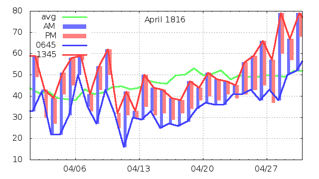
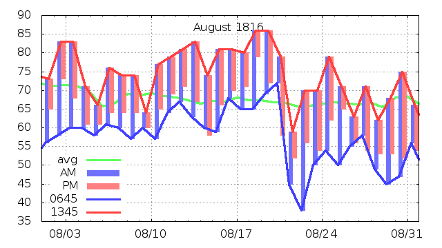
The graphics here need a little explanation. The vertical bars give an idea of how the temperature changed during the three records for each day. The blue box usually goes up from the 0645 reading to the 1345 reading, the red box goes down from the 1345 reading to the 2145 reading. The blue line connects the morning measurements and the red line connects the afternoon measurements. Remember these are rarely the low and high temperatures for the day! These show how the temperature trends during the month.
When the bars are short, local weather is often cloudy with an east wind bringing in maritime air from the Atlantic. The temperature is very close to the sea temperature, and varies from cold in the winter to chilly in the summer.
When the morning box starts low and increases more than 15-20 degrees by 1345, we pretty much always have a large high pressure system to our west or over us and light winds led to strong radiational cooling overnight. The low temperature occurs soon after sunrise. Sunlight quickly heats the temperature inversion, then the temperature climbs less quickly as air mixes with the air column.
Finally, the green line is modern data - it's the average temperature at my home near Concord, computed in a way that was popular with three reading days like we have from Epping. It's the average of the three temperatures, but with the 2145 reading counted twice. I haven't plotted the average of the Epping data, but you can deduce that visually by averaging the midpoint of a blue bar and bottom of its pink bar. I'm mostly using the modern data to give you an idea of where the extremely cold and warm periods are.
April was a good example of everything New England can dish out for ordinary weather. A few days near the 60s early in the month were welcome, but came with our familiar roller coaster weather. April 1st featured a thunderstorm, fairly rare for the date, that brought damaging lighting strikes. The 12th brought Plumer six inches of snow. After that the weather settled down for a couple weeks with chilly temperatures but steady warming. The 79 near the end of the month was probably thanks to a high pressure system moving off the coast that allowed air from the southern states to flow north. The next day a mild cold front brought things closer to average.
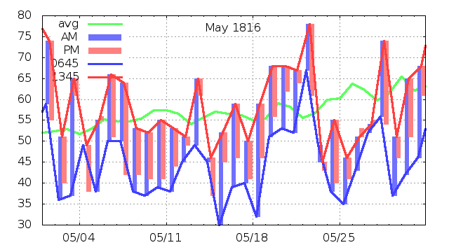
May should show overall warming. Instead, the 1345 temperature never reached that 79 in late April. Plumer notes "froze water in the night" between his entries for the 14th and 15th. (Sometimes it's ambiguous to which day his overnight notes apply.) Then he logs the bit more terse "froze in the night" for the night of the 17th. He logs "frost in the night" on the 24th, 29th, and 30th. Plumer planted new crops between April 11th and May 24th. This seems remarkably early, but I suspect farmers often tempted fate. The cost of an early crop loss is much less than a late one since you get a second chance if you can afford the seed.
Up in Lancaster, Adino Brackett also planted crops early in the month but apparently was following the calendar, writing on May 19th "this is no indication of the state of the season which has been uniformly cold. It has snowed repeatedly this month & almost every day has been foul." He wrote that during a 3 inch snow storm.
Some interesting weather: The big temperature fall between the 1st and 2nd was from a cold front and NW wind, the cold on the 4th and 5th was from NE and E wind off the Atlantic. The warm day on the 13th was a reprieve from several days of NW wind, then probably a storm that went inland on the 14th, then a return to NW winds for four more days.
The warm day on the 22nd was the end of a four day stretch of SW wind, but clouds and a little rain kept things cool. Then a powerful cold front (the 0645 temperature was the highest of the three) that "recovered" into a three day rain storm with NE winds. This has elements of a meridional jet stream with slow movement of weather systems, but still able to let cold air blow in from the north.
The month ended with another warm day with strong west winds and yet another cold front.
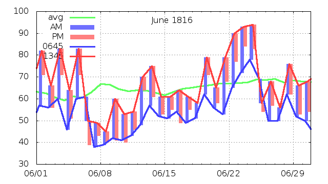
June brought one of the key events of the year. Lesser events include the roller coaster days at the start of the month thanks to NW winds on the 2nd and SE winds on the 4th interrupting the warmer SW flow of other days. The region experienced the only heatwave of the summer between the 23rd and the 25th with 1345 temperatures of 90, 93, and 94. At 4 PM on the 23rd, the thermometer reported 100! Waltham MA reported 99 and Salem MA 101. We rarely hit temperatures like that in normal years, so this is good evidence that the southern air mass was closer to average than the northern air.
And the northern air mass was behaving as though winter was not a distant memory. In Epping, the morning of the 6th started at 61 F. Five hours later it was 50 F, and the evening reading was down to 39 F. Plumer says merely "A little snow fell at Concord." On the 7th and 8th, Plumer notes the wind was "NW strong" with morning temperatures just under 40 F. Given the wind, I wouldn't expect a frost, and Plumer didn't note one, though he does note "little snow at Concord" on the 8th. On the 9th and 10th he notes water froze on the 9th, and on the 10th "At Concord water froze in this night ¼ of an inch thick. For the last 5 days fire has been necessary in the parlor of the Council chamber." (The governor presides over the Executive Council. In return the five councilors, elected from five districts in the state, approve contracts and in general keep the governor from causing too much mischief.) The cold lifted on 12th, but chilly weather was soon to return.
Other notes in Plumer's journal mentioned two inches of snow in Williamstown and that it was cool in Europe too, with snow in England on the 6th.
Meanwhile, Adino Brackett was in Concord through the end of the month. His wife, Mary, wrote from Lancaster "snow three days in succession ... corn entirely killed ... trees wear the appearance of October ... it is our duty to submit to this calamity with ... resignation as well to all others."
What were the weather patterns behind this destructive event? In 1816 they had no idea, except the usual "punishment from God" catchall. In 1924, Milham did much better with "All this can only be interpreted in terms of an extensive area of high pressure which was ushered in by strong northwest winds and snow squalls, and dominated the weather for six full days." My biggest quibble is that high pressure systems don't really get ushered in on NW winds, but help cause those winds, especially if there is a strong low pressure system off the coast heading into the Canadian maritimes.
In 2016, NH's main television station ran a retrospective report on 1816, one of the first media reports of the year. It claims that in June "a nor'easter dropped 5 to 10 inches of snow."
While a nor'easter is the most reliable way to place a low for strong winds, they come up the Atlantic coast, and I think in June, even a cold June, one will bring up enough warm air so that the event would have started out warm and then chill down. Besides, nor'easters generally influence a large enough area so that it's unlikely there could be two separate storms. Note that Plumer reported snow on the 6th and 8th, but not the 7th.
Klingaman and Klingaman have a much better handle on things, and refer to a strong low-pressure system in the Great Lakes on the 5th. This suggests that we were dealing with an "Alberta Clipper," a type of winter storm that is generally starved for moisture, moves quickly, but often "bombs out" (bombogenesis is a real Weather Service term) when it reaches the Atlantic. The small size of the storms makes it easier to accept two of them a couple days apart. Also, as the first storm bombs, the moist air it's feeding on will be pulled around the expanding first storm and help feed the second. That means the second storm can pull down more northerly, colder air and produce more snow further west than most clippers.
This appears to be what happened. While Plumer reported small snowfalls, Klingaman includes "As darkness fell on June 7, another storm brought more snow. This time Vermont scored a direct hit. Accompanied by bitterly cold winds, snow and sleet began falling Friday night.... The town of Cabot received between a foot and eighteen inches of snow...."
The Green Mountains in Vermont often extract a lot of moisture from storm systems that pass over, so it's conceivable that Vermont extracted that moisture and left drier air for New Hampshire.
Oh - one other thing. While all this was going on, a hurricane was working its way across Florida! Hurricanes generally need warm waters to start and grow. Call this another sign that the water and air in the tropical Atlantic was was not as affected as the northerly airmass.
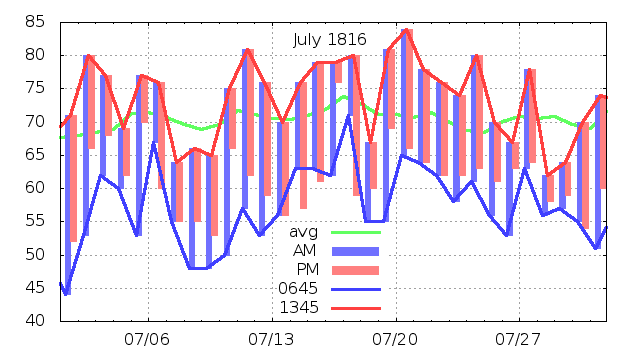
July, as is often the case, had the most boring weather of the summer. The storm track is generally well into Canada and New England spends a lot of time in the moist tropical feed from the Gulf of Mexico.
Weather at Gov. Plumer's farm was dry. In his summary for the month, he notes "Of rain there fell one inch 3 10ths & 1 20th." I.e. 1.35 inches. This is about a third of July's normal rainfall. Most of the rain fell late in the month, on the 20th and 28th. Before then Plumer's comments includes words like dust and parched.
Meanwhile, in Europe "Note in the first week of this month the fall of rain in Holland and Germany was unusually great. The dykes were broken and the inundation did great damage."
All this speaks of an extensive blocking pattern in the atmosphere forcing weather into a rut.
Up north in Lancaster, the soil moisture must have been much better, as Adino Brackett logged mid-month "... we have had fine weather every day[?] since about the 25th of June. Vegetables grow remarkably fast."
On August 9th he wrote "Through the whole of July the weather continued very warm and growing. It seems as though old times had returned."
There is a claim that there was frost or snow every month of the year in New England. While there is no hint of a frost in these reports, Klingaman and Klingaman report "On Monday July 8th, frost struck crops from Maine to Virginia. In Franconia, New Hampshire, the cold snap destroyed the bean crop. ... The morning of July 9th brought even colder temperatures and hard frosts across New Hampshire, much of Vermont, and western Massachusetts."
Let's just assume this frost was limited to low lands and depressions where radiational cooling could bring its effects. Oh, just one more thing, Plumer reported wind conditions as "NW high" every day between the 6th and 9th. The wind could still be undercut by a night-time temperature inversion, and allow a weak temperature inversion to bring its extra cooling. I may research these days further, this seems to be the most confusing event of the summer.
In his early August entry, Adino Brackett also logged "Finished haying ... Last night we had a frost, which on the hay looked quite white."
In looking back, after his comment about old times returning, he continued with "But on the first day of August a great change took place."
Unfortunately, he doesn't explain what happened, nor can we see any of this in Plumer's record, at least in the morning temperature. The dip in the afternoon temperature on the 9th is associated with northeast winds and some rain, so that's simply Atlantic maritime air and sheds little light on Lancaster weather. About all we can assume is that a Canadian outbreak made it part way into New Hampshire for the 9th and maybe earlier. Apparently it had little impact on crops.
In modern times, July and early August have the most consistent hot and humid weather of the summer. By the middle of August the first relief arrives with a Canadian high pressure system. The dew point drops from the low 70s to the 50s and that combines with the longer nights to bring good sleeping weather and a pleasantly chilly morning or two. However, we don't expect frost in either half of the month.
In my notes from Brackett's journal, I don't have other comments about August, there may be some that I didn't note because his early September weather is more dramatic.
Meanwhile, August starts out well in Epping. It's not nearly as dry as it was in July, and in the middle of the month southwest winds bring warmth greater than my modern average. Again, southerly air just doesn't show much sign of volcanic cooling. On the morning of the 20th, a cold Canadian air mass blows in and sets a new theme for the rest of the month. The morning temperature reading on the 20th was 72, the next days brought 45 and 38 - hardly "pleasantly chilly". The center of the high probably passed Epping before dawn on the 22nd, but sunrise is so close to 0645 then that must be close to the low temperature for the day.
Coincidentally, Plumer traveled northwest to Hanover for a week's worth of dealing with Dartmouth College. For his entry on the 21st, he wrote "A hard frost that in many places of vast extent killed Indian corn (particularly on river lands), potato vines, pumpkins, cucumbers etc. We shall have but a small crop of corn - that which is not killed is chilled. On Connecticut River the night fogg [Plumer's spelling] prevents early frost." (The Connecticut River is the boundary between Vermont and New Hampshire - Hanover is in the valley, well north of Concord, but well south of Lancaster.)
From his return trip on the 30th: "Found the Indian corn from Hanover to Concord that stood on prime land entirely killed by the late frosts & the stalks & leaves dry. [Unclear - I think the damage included potato tops, beans and pumpkin vines.] The prospect of the latter harvest is small, but grain of every kind abundant. Apples few till I reached Salisbury [???]. Nary about 2 thirds in quantity & 3 4ths in quality of a common crop. People busy in gathering it in."
The end of August marks the end of meteorological summer. The frost events of June and August are ultimately the key events that mark 1816 as the Year without a Summer. They stand out clearly in a temperature plot of the full summer:

Let's go one month further into this eventful year. Perhaps I'll write web pages about the weather beyond the fall harvest and into 1817.
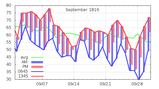
September is a month of changes. The average temperature drops some 10 degrees, the days are shortening very quickly, the first frost is likely in the north, and not a surprise in the south.
Once again, Lancaster experiences an event that simply didn't happen in Epping. On the 4th, Adino Brackett laments "This morning a dreary appearance was exhibited. Almost every vegetable was killed by the frost last night. ... So severe a frost so early in the year I have never known."
Klingaman and Klingaman talk about a cold wave starting on the 10th with frost and snow in Vermont, frozen corn and apples in Sutton NH (a few towns away from Concord). It looks like by the time the air made it to Epping, it had moderated so there was no frost. Perhaps it didn't get that far, Plumer refers to northeast wind, so the cool weather may reflect an Atlantic source rather than Canada.
A more intense frost covered the region at the end of month. By then there was little left to damage. In Plumer's monthly summary, he notes "On the 26th at sunrise at Hanover NH the thermometer was at 23, on the 27th at 20, on the 28th at 20, & on the 29th at 25."
He also notes "Of rain there fell 3 10ths of an inch." The regional drought brought fires, I suspect first distant forest fires in Canada but during September many fires in New England. Klingaman and Klingaman write of farmers' brush clearing fires getting out of control and burning woods, barns, and cattle. Even offshore, it caused shipwrecks as ships couldn't see other ships or lighthouses. Several of Plumer's comments, especially in the second half of the month refer to dense smoke.
Several other events and trends were happening in New England that interacted with the Year without a Summer and may have lingering effects today. Consider:
1816 was a trigger that led many farming families to abandon the hardscrabble farm here for the promise of more reliable farming conditions in the midwest. Some people found that the weather was just as harsh, and sometimes harsher, but with a lower risk of tropical storms and no direct hits by nor'easters, few people moved back. And the first crop of the year wasn't stones lifted by winter frost!
While some sources say the westward migration began in 1817, many people moved west in 1816. Once their crops were lost, there was little reason to stay in New England. Klingaman and Klingaman note in October that "at least several thousand refugees had passed through Zanesville [Ohio] in the past several weeks."
There are a couple interesting things in William Plumer's journal. One is that he logs the times of things like "Moon fulled 11h.20m.am." This can't be an observation, as the full moon is up all night long. Willis Milham, referring to the Williamstown record, wrote "It is interesting to note that solar spots and a change in the phase of the moon were being carefully observed. It was apparently considered at the time that these two things were the chief causes of abnormal weather."
My sense is that Plumer followed the moon phases out of farming interests, but I think Milham and I are engaging in pure speculation.
Plumer also reported on sun spots and occurrences of the Aurora Borealis. He was clearly fascinated with the latter and has some thoughts about its cause that we'd consider bizarre today, like thinking it arises from clouds, something like how wisps of steam arise from a warm pond on a cold morning.
May 1816 was the peak of what we call Solar Cycle 6. It and the predecessor were very weak cycles, and make up the "Dalton Minimum." There is some speculation that we may be entering a very similar period. The current cycle, 24, is not as weak, but some astrophysicists expect the next cycle to be similar to the old cycles. There is some evidence that we may be entering a period similar to the Maunder Minimum where we had very few spots for some 70 years.
I think some of Plumer's sun spot observations were "naked eye" observations, relying on sunset, stratus clouds, or puddles to reflect most of the light, e.g. on July 9th "A spot in the sun visible in the morning, in the center large and black." On July 10th: "At 7 O'Clock P.M. saw 2 spots in the sun near the west limb of it." Others refer to good equipment, Sept. summary: "On the 29th at Salem Ma thru a telescope 20 spots were visible on the sun."
His reports of sun spots are matter-of-fact entries, much like his reports of bird species returning in the spring, if he does connect them to weather, it likely isn't in the 1816 section.
The book Historical Climate Variability and Impacts in North America has a section on synoptic maps for the June cold spell.
American Weather Stories is a scan of this book from 1976 by Patrick Hughes of NOAA. A good account of "The Year Without a Summer" is on pages 46-54.
This past summer and fall have been so cold and miserable that I have from despair kept no account of the weather. It could have been nothing but a repeatation [sic] of frost and drought.
Contact Ric Werme or return to his home page.
Written in May 2016, last updated 2018 Jan 26.